Bay and Waterways from Port Aransas to Port O'Connor Marine Forecast
| Rest Of Today...South Wind 5 To 10 Knots. Bays Smooth. Patchy Fog Late In The Morning. |
| Tonight...South Wind 10 To 15 Knots. Bays Slightly Choppy To Occasionally Choppy. Patchy Fog In The Evening, Then Areas Of Fog After Midnight. |
| Wednesday...Southwest Wind 10 To 15 Knots Becoming North 15 To 20 Knots In The Afternoon. Bays Choppy To Occasionally Rough. |
| Wednesday Night...North Wind 20 To 25 Knots. Bays Choppy To Rough. |
| Thursday...North Wind 15 To 20 Knots. Bays Choppy To Occasionally Rough. |
| Thursday Night...Northeast Wind 10 To 15 Knots. Bays Slightly Choppy To Occasionally Choppy. |
| Friday...Northwest Wind 10 To 15 Knots Shifting West In The Afternoon. Bays Slightly Choppy To Occasionally Choppy. |
| Friday Night...South Wind 10 To 15 Knots. Bays Slightly Choppy To Occasionally Choppy. |
| Saturday...South Wind 10 To 15 Knots Increasing To 15 To 20 Knots In The Afternoon. Bays Choppy. |
| Saturday Night...South Wind Around 20 Knots. Bays Choppy To Occasionally Rough. |
| Area Forecast Discussion National Weather Service Corpus Christi TX 328pm CDT Monday April 29 2024 ...New SHORT TERM, LONG TER Marine .SHORT TERM... (Tonight through Tuesday night) Issued at 315pm CDT Monday April 29 2024 Key Messages: ▶ Low to medium chance for showers and storms tomorrow ▶ Coastal flood and high risk of rip currents will continue tomorrow A quiet radar continues this afternoon with all the convection today remaining just northeast of South Texas. Low chances for thunderstorms (less than 25%) will continue this afternoon and evening, however, if something does develop it could become severe with damaging winds and hail as the primary threats. Rain chances will decrease tonight before increasing to a low to medium chance tomorrow morning. While the upper-level forcing doesn't look impressive tomorrow, plenty of moisture (PWAT (Precipitable Water) 1.5-1.8") and vorticity in the 850 and 700 mb levels could promote showers and thunderstorms. At this time, any showers or thunderstorms that develop tomorrow are not expected to become severe. While winds continue to decrease, swell heigheights and periods continue to remain elevated, thus, continuing the threat of coastal flooding and high risk of rip currents. With current swell heigheights from Buoy 42019 coming in at 6.5-7.5 ft with swell periods between 8-9 seconds, coastal flooding could remain a concern and did not feel comfortable allowing it to expire this evening. These conditions will also lead to a continued risk of high rip currents. This will be especially noticeable in any areas of egress from the intracoastal waters as the waters from minor coastal flooding find their way back to the Gulf. Warm temperatures are expected to continue tomorrow with highs in the mid 80s to mid 90s with heat index values from the mid 90s to near 100 degrees. Overnight lows will not provide much relief as temperatures will remain warm in the 70s. Long Term (Wednesday through next Sunday) Issued at 315pm CDT Monday April 29 2024 Key Messages: - Isolated to scattered thunderstorms Wednesday through Saturday - Strong to severe thunderstorms possible Wednesday - Risk of coastal flooding to persist Wednesday and Thursday Global/mesoscale deterministic NWP (Numerical Weather Prediction) models predict upper forcing (either shortwaves or subtropical jet streaks) to affect the CWA (County Warning Area) Wednesday through Saturday. The GFS (Global Forecast System) maintains above normal PWAT (Precipitable Water) values during the period. The combination of the foregoing will maintain a slight chance/chance for convection Wednesday through Saturday. In response to one of the upper disturbances predicted to move across the central/northern Plains, a cold front is expected to approach central/southern Texas and stall. Given the addition of surface forcing, decided to increase POPs over the CWA Friday beyond that of the NBM. Concur with Storm Prediction Center with regard to a Marginal risk of severe convection Wednesday over much of CWA, as the deterministic GFS predicts CAPE/DCAPE values comparable to strong/severe and predicts BRN values consistent with multicells/supercells. The deterministic models predict a flat upper ridge to build over the region Sunday, and result in a decreasing chance for precipitation. The P-ETSS maintains waters levels, during the times of high tide, near the threshold for coastal flooding at Aransas Pass Wednesday/Thursday. Marine Issued at 315pm CDT Monday April 29 2024 Weak to moderate onshore flow will continue today through Tuesday night with a low chance for showers and thunderstorms this evening and tonight and a medium chance tomorrow. Seas are expected to continue to gradually subside this afternoon dropping below 7 feet late this afternoon and allowing for the Small Craft Advisory to expire. The combination of upper disturbances and moist conditions will contribute to isolated showers and thunderstorms Wednesday through Friday. NOAA Corpus Christi TX Office: Watches - Warnings - Advisories TX...Coastal Flood Advisory until 7pm CDT Tuesday for TXZ245-342>347- 442-443-447. High Rip Current Risk through Tuesday evening for TXZ345-442-443- 447. GM...Small Craft Advisory until 7pm CDT this evening for GMZ250-255- 270-275. |
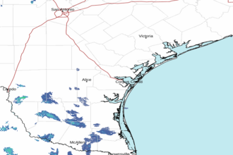 Corpus Christi TX Radar
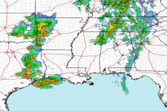 Gulf Radar