Bays and Waterways from Baffin Bay to Port Aransas Marine Forecast
| Rest Of Today...Southeast Wind 5 To 10 Knots. Bays Smooth. |
| Tonight...Southeast Wind Around 10 Knots Shifting South After Midnight. Bays Slightly Choppy To Occasionally Choppy. A Slight Chance Of Showers And Thunderstorms In The Evening. Patchy Fog In The Evening. Areas Of Fog After Midnight. |
| Wednesday...Southwest Wind 10 To 15 Knots Becoming North 15 To 20 Knots In The Afternoon. Bays Choppy To Occasionally Rough. Patchy Fog In The Morning. |
| Wednesday Night...North Wind 20 To 25 Knots. Bays Choppy To Rough. |
| Thursday...Northeast Wind 15 To 20 Knots. Bays Choppy To Occasionally Rough. |
| Thursday Night...Northeast Wind 10 To 15 Knots. Bays Slightly Choppy To Occasionally Choppy. |
| Friday...North Wind 10 To 15 Knots Shifting Southeast In The Afternoon. Bays Slightly Choppy To Occasionally Choppy. |
| Friday Night...Southeast Wind 15 To 20 Knots Becoming South 10 To 15 Knots After Midnight. Bays Choppy. |
| Saturday...South Wind 10 To 15 Knots Becoming Southeast 15 To 20 Knots In The Afternoon. Bays Choppy. |
| Saturday Night...Southeast Wind Around 20 Knots. Bays Choppy To Occasionally Rough. |
| Area Forecast Discussion National Weather Service Corpus Christi TX 104pm CDT Monday April 29 2024 Long Term (Tuesday night through next Sunday) Issued at 228am CDT Monday April 29 2024 Key Messages: ▶ Daily low to medium (20-40%) chance of showers and thunderstorms over South Texas ▶ Moderate risk of heat-related impacts Wednesday and Thursday An unsettled weather pattern ahead as a sub-tropical jet at 250mb combined with mid-level shortwaves and well above normal moisture will lead to daily low to medium (20-40%) shower and thunderstorm chances across South Texas. Most favorable conditions occur Thursday into Friday as stronger shortwaves combine with an approaching cold front. A deep low over the northern Great Plains swinging eastward on Friday, will reflect a surface cold front into Texas. This cold front will likely come to a halt north of South Texas over the Hill Country but pre-frontal surface troughing leads to an increase to medium rain chances and a slight directional wind shift through Friday. There is a very high (80-95%) chance of SBCAPE over 2000 J/kg across portions of South Texas Wednesday through Friday with a weakening cap during the midday and afternoon hours; this will further favor our thunderstorm chances during the day. Additional mid-level shortwaves move across the area during the weekend and will therefore maintain a low chance (10-30%) of showers and thunderstorms. But confidence lowers heading towards the end of the long term as cap increases, model discrepancies become more apparent, and upper-level ridging amplifies with an embedded shortwave counteracting. High temperatures range from the mid 80s to mid 90s and induce a moderate risk of heat-related impacts to portions of South Texas through Friday, with greatest concern Wednesday and Thursday across all of South Texas. This risk poses the greatest threat to individuals sensitive to heat and those without effective cooling and/or hydration. Please make sure to drink plenty of water and take frequent breaks if outdoors! Last but not least, swell periods near 8 seconds and moderate onshore flow could lead to greater wave runup and an increased risk of minor coastal flooding and rip currents. However, confidence is low as astronomical tide is lowering through the middle of the week. Marine Issued at 228am CDT Monday April 29 2024 A Small Craft Advisory will remain in effect over the coastal waters through this afternoon as wave heigheights remain elevated. Wave heigheights will subside this afternoon, leaving us with light to moderate onshore flow. There is a low to moderate chance of showers and thunderstorms today through Tuesday. There is medium confidence in patchy to areas of fog late tonight. Weak to moderate onshore flow Tuesday night through Wednesday will strengthen to moderate Wednesday night through Thursday night. Onshore winds back down to weak to moderate Friday into the weekend. There is a low chance, 20 to 30 percent, of showers and thunderstorms daily Wednesday through Saturday. NOAA Corpus Christi TX Office: Watches - Warnings - Advisories TX...Coastal Flood Advisory until 7pm CDT this evening for TXZ245- 342>347-442-443-447. High Rip Current Risk through Tuesday morning for TXZ345-442-443- 447. GM...Small Craft Advisory until 1pm CDT this afternoon for GMZ250- 255-270-275. |
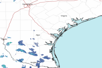 Corpus Christi TX Radar
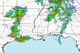 Gulf Radar