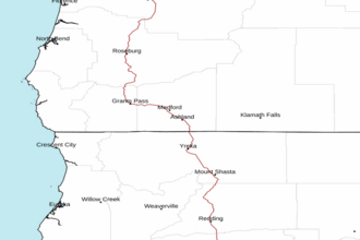
Cape Blanco OR to Point St. George CA from 10 to 60 NM Marine Forecast
| Today...Nw Wind 10 To 15 Kt. Wind Waves Nw 3 Ft At 5 Seconds. Swell Nw 7 Ft At 10 Seconds. Chance Of Rain. |
| Tonight...Nw Wind 10 Kt...Backing To W Early In The Morning. Wind Waves Nw 2 Ft At 5 Seconds. Swell Nw 7 To 8 Ft At 10 Seconds. |
| Tue...Nw Wind 10 To 15 Kt. Wind Waves Nw 4 Ft At 5 Seconds. Swell Nw 7 To 9 Ft At 11 Seconds. Chance Of Rain. |
| Tue Night...N Wind 10 Kt Northern Portion And N 10 To 20 Kt Southern Portion. Wind Waves Nw 3 Ft At 6 Seconds. Swell Nw 8 To 9 Ft At 11 Seconds. |
| Wed...Northern Portion, N Wind 10 To 15 Kt. Southern Portion, N Wind 15 To 20 Kt...Rising To 20 To 25 Kt In The Afternoon. Wind Waves N 3 Ft At 4 Seconds. Nw Swell 7 Ft At 10 Seconds... Subsiding To 5 To 6 Ft At 10 Seconds In The Afternoon. |
| Wed Night...Northern Portion, N Wind 10 To 15 Kt. Southern Portion, N Wind 20 To 25 Kt...Easing To 15 To 20 Kt After Midnight. Wind Waves N 4 Ft At 5 Seconds. Nw Swell 5 To 6 Ft At 9 Seconds...Subsiding To 3 Ft At 9 Seconds After Midnight. Chance Of Rain. |
| Thu...Nw Wind 10 Kt...Veering To N. Wind Waves Nw 3 Ft At 4 Seconds. Swell Nw 3 To 4 Ft At 8 Seconds. |
| Fri...N Wind 10 Kt...Backing To W. Wind Waves Nw 3 Ft At 4 Seconds. Swell Nw 3 To 4 Ft At 8 Seconds. |
| Area Forecast Discussion National Weather Service Medford OR 1111am PDT Monday April 29 2024 Marine Updated 830am Monday, April 29, 2024...Seas will be elevated and hazardous to small craft today through Tuesday morning due to a combination of wind seas and increasing west northwest swell. Low pressure will move north of the waters Tuesday with seas transitioning to high and steep WNW swells near 10 feet Tuesday afternoon and evening. Weak high pressure will move in Wednesday with moderate north winds, highest south of Cape Blanco. Then, another front will move through the waters Wednesday night and onshore Thursday. Calmer conditions are expected Friday. -Spilde /Issued 442am PDT Monday April 29 2024/ Satellite imagery this morning looks a lot like it has for the past few mornings...widespread cloud cover along and west of the Cascades with mostly clear skies east of the Cascades and south of the Siskiyous. Radar imagery and surface observations indicate light shower activity along the coast and into the Umpqua Basin. Rinse and repeat is in store through at least midweek as WNW flow aloft maintains onshore flow with multiple disturbances passing through the Pacific Northwest. We'll remain on the southern fringes of these shortwave troughs, so precipitation chances will continue to be highest (60-90% chance) along the coast and north of the Rogue- Umpqua Divide and into the Cascades north of Lake of the s. It'll be dry for areas south and east of those locations (though an isolated shower or two can't be ruled out) with gusty breezes (25-35 mph) developing in the afternoons through Tuesday. Snow levels will hover around 3500-4000 ft today as the next disturbance passes through, but any snow accumulations will be confined to the mountains generally above 4500 feet. Highest amounts will be from about Crater Lake northward, where 2-5" could accumulate. Up to an inch of snow is possible over Highway 140 near Lake of the s with a skiff also possible on parts of Highway 97 north of Chiloquin. So, if traveling early this morning, be aware of the potential for some slick spots in those areas. This system exits to the east this evening, so shower chances diminish, but it will be followed by another upper disturbance that will swing through northern Oregon Tuesday and into Idaho Tuesday night into Wednesday. Similar to the disturbance expected today, PoPs (for showers) will be highest across the north, lowest across the south. Snow levels bottom out near 2500 feet Tuesday morning, but again most, if not all, snow accumulation will be in the mountains north of Crater Lake with even less accumulations expected than today's system. The upper trough will exit to the east Tuesday night into Wednesday, so precipitation chances drop to almost nil. A few cold mornings are in store for West Side Valleys both Tuesday and Wednesday mornings, and there will be some potential for frost/freeze conditions. On Tuesday morning, the concern looks to be limited to the Illinois Valley and the typically colder locations. Confidence in freeze potential for Tuesday morning is limited by potential lingering cloud cover. However, there could be a few hours of clearing just after midnight tonight before cloud cover increases again with the next disturbance moving in on Tuesday. A Freeze Watch remains in effect for this potential, and details can be found at NPWMFR. For Wednesday morning, the frost/freeze potential looks more widespread for West Side Valleys (increasing to 25%-50% chance) due to more widespread clearing of skies. Additional freeze products are likely to follow in the next few shifts. Heigheights rise on Wednesday as the upper trough continues to shift to the east, resulting in at least partial sunshine with a dry and slightly milder afternoon (high temps back closer to seasonal normals). However, yet another upper trough coming out of the Gulf of Alaska Wednesday night will skim by to our north on Thursday. As has been the case for recent systems, models are showing most of the precipitation staying well to our north, but a 20-30% chance of showers persists for areas along the coast and across northern Douglas County. Modest warming will continue with highs in the upper 60s to low 70s west of the Cascades and generally in the mid 60s over the East Side. Confidence is increasing in the overall pattern expected for late week and into the weekend, though confidence in details remains low at this point. Friday should be a dry day for most as a shortwave ridge passes through the region and temperatures trend warmer by a few degrees compared to Thursday. Details become fuzzy Friday night into the weekend. Cluster analysis indicates that about 90% of the solutions bring some semblance of a trough affecting the region this weekend, but the question is how deep/strong is the trough? Of that 90% of solutions, about a third of them (dominated by the EC) lean toward a weak trough while the remaining 60% show a deeper/stronger trough, but are split on the location of the trough. These differences make it challenging to be confident in details at this point, but overall, it looks like a general trend of lower temperatures with increasing and more widespread precipitation chances can be expected for the weekend. -Spilde/BR-y approaching front will result in enough instability to keep ceilings at VFR for most of the TAF period. However could not rule out MVFR (Marginal Visual Flight Rules) ceilings in moderate showers mainly between 17 and 0z. Elsewhere, VFR conditions will be the predominate condition. However partial terrain obscurations are possible between 15z and 0z along and west of the Cascades and Siskiyous. Winds will increase at Medford later in the afternoon. Winds will increase east of the Cascades between 16-17z, with peak gusts around 25 kts at Klamath Falls. -Petrucelli NOAA Medford OR Office: Watches - Warnings - Advisories OR...Freeze Watch from late tonight through Tuesday morning for ORZ024. CA...None. PACIFIC COASTAL WATERS...Small Craft Advisory from 5pm this afternoon to 11pm PDT Tuesday for PZZ356-376. Small Craft Advisory until 11pm PDT Tuesday for PZZ350-370. |
 Medford OR Radar
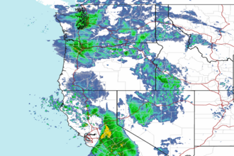 Northwest Radar