Cape Flattery to James Island WA out 10 NM Marine Forecast
| Today...W Wind 5 To 15 Kt. Wind Waves 1 To 2 Ft. W Swell 7 Ft At 10 Seconds. |
| Tonight...Sw Wind 10 To 20 Kt Becoming S 5 To 15 Kt After Midnight. Wind Waves 2 To 4 Ft. W Swell 8 Ft At 11 Seconds. |
| Tue...Ne Wind To 10 Kt Becoming N In The Afternoon. Wind Waves 1 To 3 Ft. W Swell 9 Ft At 11 Seconds. |
| Tue Night...Nw Wind 15 To 20 Kt Easing To 5 To 15 Kt After Midnight. Wind Waves 2 To 4 Ft Subsiding To 1 To 2 Ft After Midnight. W Swell 7 Ft At 10 Seconds. |
| Wed...W Wind 5 To 15 Kt Becoming Sw In The Afternoon. Wind Waves 1 To 2 Ft. W Swell 4 Ft At 7 Seconds. |
| Wed Night...S Wind 10 To 20 Kt Becoming 15 To 20 Kt After Midnight. Wind Waves 2 To 4 Ft. Sw Swell 5 Ft At 7 Seconds. |
| Thu...Sw Wind 5 To 15 Kt. Wind Waves 1 To 2 Ft. W Swell 4 Ft. |
| Fri...Se Wind 5 To 15 Kt. Wind Waves 1 To 3 Ft. W Swell 3 Ft. |
| Area Forecast Discussion National Weather Service Seattle WA 1032am PDT Monday April 29 2024 Convergence zone that was over Seattle earlier this morning has moved into the Cascades. Doppler radar shows scattered showers off the coast and over the Northwest Interior. Very cold upper level trough overhead ( 500 mb temp near -35C ) keeping unstable air mass in place. Expect shower coverage to increase this afternoon. Snow totals Sunday evening through this morning, 6 or 7 inches at Paradise on Mount Rainier and White Pass, 2 or 3 inches at Stevens Pass and 9 or 10 inches at Mount Baker. Current forecast has the trends covered. No update this morning. Previous discussion follows with small changes to aviation and marine sections. Short Term - Today through Wednesday Complex weather picture next 36 hours with a system passing through. An upper level low is tracking southward from B.C. Canada southward into Washington today. This is driving a jet streak with upper level divergence/low level convergence over the state, which combined with a 500 mb vorticity max. provides a lifting mechanism for precipitation. The temperatures with this low at the mid levels are unusually cool for this time of year, with 500 mb temperatures at -30 to -35 C. Satellite also shows a surface low over Haida Gwaii, with an associated surface trough boundary tracking southeastward with the previously mentioned upper-level features. From this morning, convergence zone showers over Skagit/Whatcom counties dissipated. Radar shows an apparent meso-low rotating convective showers inland from Clearwater to Chehalis. Hi-res model guidance shows this feature tracking into Puget Sound during the early morning hours, which will cause a wet commute for most areas in the sound. Coverage of showers will increase this morning into the afternoon with multiple rounds making their way through the coverage area. Storm Prediction Center has all of western Washington in a general thunder risk for Monday (as well as Tuesday in the Southwest Interior). With the cool air aloft and upper air dynamics, this will cause the atmosphere to become unstable throughout the day. Given CAPE values up to 200 J/kg (with little CIN), 0-6 km shear 35-40 kt, and SRH 80-100 m2/s2, a couple organized thunderstorm cells are possible with the shower activity that develops. Exact location of the thunder activity is hard to pinpoint at this time, but Hi-res guidance suggests a convergence zone developing Monday afternoon over Island/Snohomish/King counties, with some additional cells forming in south Puget Sound, and the coast/Southwest Interior. The strongest cells may be capable of producing small hail and gusty winds, as well as lightning. Activity is expected to last through Monday night/Tuesday morning. For the mountains, moderate snow remains on track to fall in the Cascades today. A couple of rounds of snow are expected in the morning and afternoon/evening. Based on snow levels dropping quickly to around 2,000-2,500 ft, and above freezing temperatures from these snow levels to around 3,500 ft, snow is not expected to be impactful at these levels (including Snoqualmie Pass). Below freezing surface temperatures at 3,500 ft and higher will cause snow to stick to surfaces. Snowfall rates are expected to range from a quarter of an inch to half an inch an hour (with any convective banding capable of brining rates to 1 inch an hour). With confidence that snowfall will last through Monday evening, the winter weather advisory was extended to 2am PDT (for elevations greater than 3,500 ft - including Snoqualmie Pass). Snow totals are expected to range from 4 to 8 inches, with heavier amounts possible with any convective snow banding that materializes. Shower activity will continue through first part of Tuesday. As the low departs, a weak upper level ridge will dry the region out late Tuesday/early Wednesday. A weakening surface system/upper level trough will return the chance of showers Wednesday afternoon. High temperatures will range from the 50s in the lowlands, to the 30s and 40s in the mountains. Lows will dip down into the upper 30s and 40s in the lowlands, and the 20s/30s in the mountains. Winds will remain light around 5 to 10 mph. Long Term - Thursday Through Sunday Still a lot of disagreement between ensemble/deterministic models with the long-term pattern. With most models showing troughing in the extended, a chance of showers will be possible Thursday into the weekend. Heavy precipitation in the Southwest Olympic region is possible Thursday and Sunday, but confidence is low due to variations in the models. Temperatures return into the mid 60s by Friday into the weekend. Winds are expected to be light. HPR Marine Active and unsettled weather continues as we move into the new workweek. Showers, some convective in nature with isolated lightning strikes, will continue to skirt across the area waters today into tonight as a pair of mid-level disturbances pivot southeast beneath a longwave trough, driving a pair of weak surface lows across the southern Washington offshore zones this morning and Tuesday. Breezy winds will continue today, though opted to issue Small Craft Advisories through the central and eastern Strait of Juan de Fuca, where confidence is highest for wind gusts over 21 kt (80%). Brief and more isolated advisory-level wind gusts cannot be ruled out elsewhere with the convective showers today, though confidence is too low for additional advisories. Seas from 8 to 10 feet this morning will drop closer to 7 to 9 feet later today, then rise back to 8 to 10 feet into Tuesday as the next weak surface low traverses the area waters. Seas then look to subside to 4 to 7 feet Wednesday into the latter half of the week. Hydrology No river flooding expected over the next seven days. NOAA Seattle WA Office: Watches - Warnings - Advisories WA...Winter Weather Advisory until 2am PDT Tuesday for West Slopes North Cascades and Passes-West Slopes North Central Cascades and Passes-West Slopes South Central Cascades and Passes. PZ...Small Craft Advisory until 10pm PDT this evening for Central U.S. Waters Strait Of Juan De Fuca. Small Craft Advisory until 10pm PDT this evening for East Entrance U.S. Waters Strait Of Juan De Fuca. |
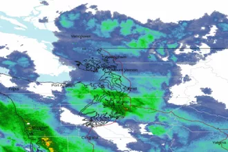 Seattle/Tacoma WA Radar
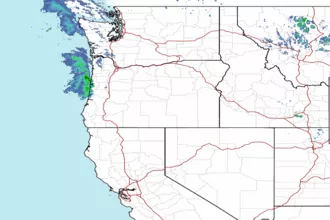 Northwest Radar