Charleston Harbor Marine Forecast
| This Afternoon...S Winds 10 To 15 Kt. |
| Tonight...S Winds 5 To 10 Kt. |
| Tue...S Winds 5 To 10 Kt, Increasing To 10 To 15 Kt With Gusts To 20 Kt In The Afternoon. |
| Tue Night...S Winds 10 To 15 Kt. A Slight Chance Of Showers And Tstms After Midnight. |
| Wed...Sw Winds 5 To 10 Kt. A Slight Chance Of Showers And Tstms. |
| Wed Night...Sw Winds 5 To 10 Kt. A Slight Chance Of Showers And Tstms In The Evening. |
| Thu...Ne Winds 10 To 15 Kt. |
| Thu Night...E Winds 5 To 10 Kt. |
| Fri...E Winds 5 To 10 Kt. |
| Fri Night...Se Winds 5 To 10 Kt. Winds And Waves Higher In And Near Tstms. Unless Otherwise Noted, Waves 1 Foot Or Less. Charleston Harbor Water Temperature 71 Degrees. |
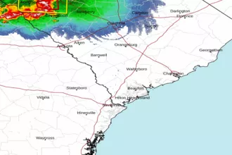
| Area Forecast Discussion National Weather Service Charleston SC 144pm EDT Monday April 29 2024 Synopsis High pressure will prevail through much of the week. A weak disturbance will move through Tuesday and Wednesday, then a weak cold front will stall in the vicinity this weekend. Near Term - Through Tonight This Afternoon: Aloft, the main axis of a mid-upper level ridge will be placed across the Southeast United States through much of the day, then show signs of shifting offshore late as a trough shifts across parts of the Deep South. At the sfc, high pressure centered across the Atlantic will extend across the local area, favoring an onshore wind that slowly veers from east to south-southeast during the afternoon. Strong insolation throughout the day and 1000-850 mb thickness levels support max temps a few degrees warmer than the previous day, generally ranging in the low-mid 80s away from the coast. At the beaches, the onshore wind/seabreeze shifting inland will limit high temps to the mid-upper 70s. Tonight: While the Atlantic high at the surface remains in control, the ridge aloft is nudged east in advance of a short wave that is initially near the ArkLaTex and reaches near the southern Appalachians late. There might be a few showers out near the Gulf Stream, but nothing over land areas. We'll be able to radiate decently early on, under mainly clear skies and light winds. But an increase in cirrus clouds with the short wave will arrive from the west late, and that along with the formation of some late night stratus, will prevent us from getting as cool as Monday morning. Lows will be mainly upper 50s and lower 60s, with middle 60s closer to the shore, and in the metro areas of Charleston, North Charleston, and Savannah. There remains enough boundary layer moisture to potentially produce some late night fog well inland, especially if stratus does occur. Short Term - Tuesday Through Thursday A pronounced upper shortwave will slowly move through the area Tuesday into Wednesday. A decent slug of moisture will accompany the feature with PWATs (Precipitable Waters) around 1.25". Surface-based CAPEs (Convective Available Potential Energy - high values indicate potential for severe weather) will be 500-1000 J/kg Tuesday and Wednesday. Isolated to scattered showers and thunderstorms possible Tuesday and Tuesday night. The shortwave is expected to move off the coast by late Wednesday morning, however some guidance hints at a weak surface trough lingering over southern SC into Wednesday afternoon. There could be just enough moisture and convergence to support a few showers or thunderstorms Wednesday afternoon, especially across the northern half of the area. Tuesday highs will be in the mid 80s and Wednesday will be mid/upper 80s. Deep layered ridging will occur on Thursday, yielding a dry and toasty day with highs in the upper 80s to lower 90s. Long Term - Thursday Night Through Sunday The upper ridge will persist into Friday before pushing off the coast over the weekend. Then, a quasi-zonal flow will develop with a series of shortwaves rippling through. Greater coverage of mainly diurnal convection expected during this period. Above normal temps will persist with highs in the mid/upper 80s. Marine This Afternoon and Tonight: High pressure centered across the western Atlantic will extend across region, maintaining quiet marine conditions across local waters. Even with a subtle boost from a seabreeze circulation early afternoon, east winds veering to south-southeast will peak no higher than 10-15 kt. Seas will range between 2-4 ft, largest across offshore Georgia waters. Atlantic high pressure will remain the dominant feature Tuesday through Saturday, with winds generally no higher than 10-15 kt and seas 2-4 ft. A moderate coastal sea breeze will develop each afternoon. Rip Currents A small swell every 9 or 10 seconds, and continued onshore winds, will result in a Moderate Risk of rip currents at all beaches today. NOAA Charleston SC Office: Watches - Warnings - Advisories GA...None. SC...None. Marine None. |
 Charleston SC Radar
 Southeast Radar