Chesapeake Bay from Windmill Point to New Point Comfort VA Marine Forecast
| Through 7 Pm...S Winds 5 To 10 Kt. Waves 1 Foot. |
| Tonight...Sw Winds 10 Kt. Waves 1 Foot. |
| Tue...Sw Winds 10 To 15 Kt. Waves Around 2 Ft. |
| Tue Night...Sw Winds 10 To 15 Kt. Waves Around 2 Ft. |
| Wed...Sw Winds 5 To 10 Kt, Becoming Nw In The Afternoon. Waves 1 Foot. A Chance Of Showers. |
| Wed Night...E Winds 5 To 10 Kt. Waves 1 Foot. A Chance Of Showers In The Evening. |
| Thu...E Winds 10 Kt. Waves 1 Foot. |
| Thu Night...Se Winds 5 To 10 Kt. Waves Around 2 Ft In The Evening, Then 1 Foot Or Less. |
| Fri...Se Winds 5 To 10 Kt. Waves 1 Foot, Then Around 2 Ft In The Afternoon. |
| Fri Night...Se Winds 10 To 15 Kt. Waves Around 2 Ft. |
| Area Forecast Discussion National Weather Service Wakefield VA 431pm EDT Monday April 29 2024 Synopsis High pressure will shift farther off the Southeast coast and out to sea tonight through Wednesday. Well above normal temperatures are expected through much of the week. A weak cold front will cross the area late Tuesday night through Wednesday with scattered showers and storms possible Wednesday into Wednesday evening. Precipitation chances increase this weekend, as another cold front approaches the area. Near Term - Until 6am Tuesday Morning As of 400pm EDT Monday... Late this afternoon. surface high pressure was centered off the SE coast. Very warm under a sunny or mostly sunny sky, with temps ranging through the 80s. The high will start to shift a little farther off the SE coast tonight, as a weak cold front pushes through the OH/TN valleys. Clear or mostly clear and mild tonight with lows in the upper 50s to lower 60s. Short Term - 6am Tuesday Morning Through Thursday As of 400pm EDT Monday... The surface high will shift farther off the SE coast and out to sea tonight through Wed. Still very warm on Tue, with a mostly sunny sky becoming partly sunny, as a weak cold front starts to approach from the WNW. Highs will mainly be in the lower to mid 80s. That front will then gradually push into and across the region Tuesday evening through Wednesday evening. There may be isolated showers or a tstm Tuesday evening into Wednesday morning. But then, the best chance for showers/thunderstorms (30-54%) will be from late Wednesday morning into Wednesday evening, as the boundary slowly sinks SE through the area. Lows Tuesday night in the lower to mid 60s, with highs on Wednesday in the mid 70s to lower 80s. The highest Probability of Precipitation will be across srn/SE counties where around ~0.25" of rain will be possible. The rain will end Wednesday night with dry weather expected for late Wednesday night through Thu, as the front pushes SSE of the area and upper ridge of high pressure builds into/over the region. Lows will range through the 50s Wednesday night, with highs on Thu ranging from the upper 60s to mid 70s near the Bay/coast, to the upper 70s to lower 80s inland/Piedmont. Long Term - Thursday Night Through Monday As of 415pm EDT Monday... High pressure ridge aloft will maintain dry weather Thu night through Fri. At the sfc, high pressure will be centered over New England or just offshore, resulting in onshore flow everywhere. This will keep temps cooler along the coast and warmer inland. Highs on Fri in the lower to mid 80s inland/Piedmont, and in the mid 70s near the Bay/coast (coolest along the Atlantic beaches of the Eastern Shore). There may be an isolated shower or tstm Fri evening/night over WNW counties, as a cold front starts to approach from the WNW. A cold front will gradually push into and across the region Sat into Mon, providing decent chances for showers/thunderstorms. Due to plenty of cloud cover expected, highs will range through the 70s into the lower 80s. Marine As of 300pm EDT Monday... Generally benign, sub-SCA (Small Craft Advisory) conditions, are expected through the forecast period though some gusts to around 20 kt are possible at times. High pressure remains centered off of the Carolinas with an area of low pressure west of the Great Lakes. This is placing the region under a persistent southwest flow around 10 to 15 knots. Seas persist around 2 to 3 feet (up to 4 feet offshore), and waves in the bay are running around 1 foot (up to 2 feet at the mouth). Southwesterly flow continues overnight and decreases with the loss of mixing. For Tuesday southwest winds should increase a little after daybreak with mixing resulting to 10 to 15 kt with a few higher gusts possible over the Bay and near shore waters closer to land. A cold front approaches the waters from the north and northwest late Tuesday night pushing south past Ocean City and the Potomac River in the morning reaching the lower Bay and NC waters later in the afternoon. S to SW winds will increase slightly ahead of the front (~15 knots over the bay and ~15 to 20 knots over the coastal waters) Tuesday afternoon into Tuesday evening. Seas increase some due to the stronger S winds, with seas approaching 4 to 5 feet out 20 nm, especially north of Cape Charles Light. Winds shift to the N and NE behind the front Wednesday morning and remain around 10 to 15 kt. Generally onshore flow from the NE then E is expected from late Wednesday into Friday. Have increased the NE winds a little with this forecast updated based on the models, but winds remain below SCA (Small Craft Advisory) criteria around 15 kt with some gusts to near 20 kt possible at times. Another front potentially approaches the waters later this weekend. Climate Record highs for April 29th and April 30th: 4/29 4/30 RIC 94/1974 93/1974 ORF 92/1974 93/1988 SBY 89/1974 86/2017 ECG 90/1974 90/1974 NOAA Wakefield VA Office: Watches - Warnings - Advisories MD...None. NC...None. VA...None. Marine None. |
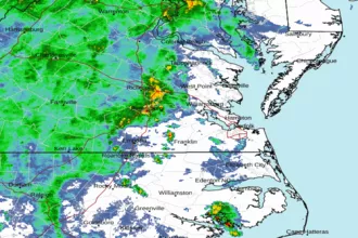 Wakefield Norfolk VA Radar
 Northeast Radar
 East Coast Satellite