Neuse River & Bay River Marine Forecast
| Tonight...Sw Winds 10 To 15 Kt. Waves A Moderate Chop. |
| Tue...Sw Winds 10 To 15 Kt. Waves A Moderate Chop. |
| Tue Night...Sw Winds 10 To 15 Kt. Waves A Moderate Chop. A Slight Chance Of Showers After Midnight. |
| Wed...Sw Winds Around 10 Kt. Waves Light Chop. A Chance Of Showers. A Chance Of Tstms In The Afternoon. |
| Wed Night...Sw Winds 5 To 10 Kt. Waves Light Chop. A Chance Of Showers And Tstms, Mainly In The Evening. |
| Thu...Ne Winds 5 To 10 Kt, Becoming E In The Afternoon. Waves Light Chop. |
| Thu Night...E Winds 5 To 10 Kt. Waves Light Chop. |
| Fri...E Winds 5 To 10 Kt. Waves Light Chop. |
| Fri Night...E Winds 5 To 10 Kt. Waves Light Chop. |
| Sat...Se Winds 5 To 10 Kt. Waves Light Chop. |
| Sat Night...Se Winds Around 10 Kt. Waves Light Chop. Winds And Waves Higher In And Near Tstms. |
| Area Forecast Discussion National Weather Service Newport/Morehead City NC 314pm EDT Monday April 29 2024 Synopsis High pressure will remain anchored offshore through mid week. A cold front will impact the area late in the week. Near Term - Through Tonight As of 300pm Mon...Very quiet weather pattern in place over the eastern CONUS this afternoon. Mid-level ridge remains overhead today as high pressure centered over the Atlantic extends onshore. This pattern will remain in place tonight, with continued southwesterly flow keeping overnight temperatures mild under clear skies - upper 50s to low 60s. Guidance has backed off a bit on low stratus potential overnight, with now only the NAM and ARW advertising such development. Both of these models have a history of being too aggressive in showing low stratus in south to southwesterly flow, and given the lack of support from any other guidance (including a reliable GFS (Global Forecast System) LAMP) did not reflect this in the forecast. Short Term - Tuesday As of 300pm Monday...Upper ridge will begin to break down tomorrow as a strengthening shortwave trough, currently digging into eastern Texas, shifts eastward. Attendant surface low pressure/trough will also move across the southeastern CONUS, bringing unsettled weather ahead of it. Eastern NC will remain under the influence of the ridge into Tuesday evening, keeping conditions dry but with increasing high clouds as upper level moisture increases. The minority of guidance quickest with the surface trough/low does show some isolated shower activity impacting the coastal plain around sunset tomorrow, but probability of this is too low (under 10%) to include mentionable PoPs. Temperatures will be a degree or two warmer than today, in the low to mid 80s inland. Long Term - Tuesday Night Through Monday As of 330am Monday... KEY MESSAGES - Low to mid 80s for the rest of the week - Best rain chances Wednesday and then this weekend FORECAST DETAILS Dry weather should prevail Tuesday with the system not making its way to ENC until Wednesday. With this disturbance expected to pass during Wednesday's peak heating, showers and thunderstorms are possible across the area (30-55% chance). Although thunderstorms are possible, severe storms are less likely as very little shear is expected. Thursday has trended drier for showers and thunderstorms with PoPs below slight chance. Temperatures will remain high with upper 80s inland to mid to upper 70s along the coast. A little more moisture advection Saturday and Sunday with both the Bermuda High and an approaching frontal system from the west contributing to the increase in precipitable water. Increasing chances for rain and thunderstorms (35-40%) by Saturday afternoon and then lingering into Sunday as the front moves into the region. Temperatures slightly cooler both days but still well above normal for this time of year. Marine SHORT TERM /through Tuesday/... As of 310pm Tuesday...Quiet boating conditions in place this afternoon over area waters as high pressure remains anchored to our southeast. Regional observations show southwesterly winds of 10-15 kt with seas averaging 3 feet with periods of 10-11 seconds. Little change in these conditions are expected through the period. Like yesterday, an increase in winds across the northern waters and sounds with a tightening thermal gradient is expected and a few spotty gusts to 25 kt are possible. This is not expected to last long enough to warrant SCA. A similar pattern is expected tomorrow, although for a broader swath of near-shore waters. Long Term - Tuesday Through Friday As of 330pm Sunday... KEY MESSAGES - Good boating conditions expected early this week FORECAST DETAILS High pressure will shift offshore early this week, with inland troughing developing in the lee of the Appalachians. Winds will steadily increase early next week with southwesterly flow of 10-20kt common. Seas of 3-5 ft will be common through early next week, setting up good boating conditions for several days. NOAA Newport/Morehead City NC Office - Watches - Warnings - Advisories NC...None. Marine None. |
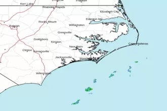 Newport NC Radar
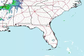 Southeast Radar
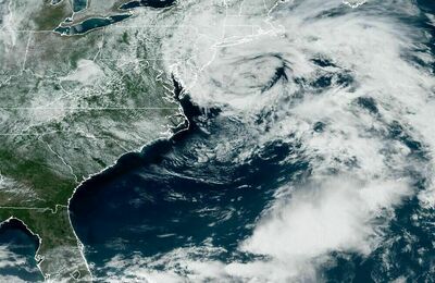 East Coast Satellite