Penobscot Bay Marine Forecast
| Tonight...N Winds 5 To 10 Kt. Seas Around 2 Ft This Evening, Then 1 Foot Or Less. |
| Tue...N Winds 5 To 10 Kt With Gusts Up To 20 Kt, Becoming Sw In The Afternoon. Seas 1 Foot Or Less. |
| Tue Night...Sw Winds 5 To 10 Kt, Becoming Nw After Midnight. Seas 1 Foot Or Less. A Chance Of Showers. Patchy Fog After Midnight With Vsby 1 To 3 Nm. |
| Wed...E Winds Around 5 Kt, Becoming Se In The Afternoon. Seas 1 Foot Or Less. A Chance Of Showers In The Morning. |
| Wed Night...Sw Winds Around 5 Kt, Becoming Nw After Midnight. Seas 1 Foot Or Less. |
| Thu...E Winds Around 5 Kt, Becoming S In The Afternoon. Seas 1 Foot Or Less. |
| Thu Night...Se Winds 5 To 10 Kt, Becoming Ne After Midnight. Seas 1 Foot Or Less. |
| Fri...Ne Winds Around 10 Kt. Seas Around 2 Ft In The Morning, Then 1 Foot Or Less. |
| Fri Night...Ne Winds 5 To 10 Kt. Seas 1 Foot Or Less. |
| Sat...Ne Winds Around 10 Kt, Becoming Se In The Afternoon. Seas 1 Foot Or Less. |
| Sat Night...S Winds 5 To 10 Kt. Seas 1 Foot Or Less. |
| Area Forecast Discussion National Weather Service Gray ME 256pm EDT Monday April 29 2024 Synopsis Cool winds off the Atlantic will develop for Tuesday and Wednesday with a few showers and temperatures below normal as the calendar changes from April to May. Shower chances continue for later this week with temperatures slowly climbing. An early look at the coming weekend shows seasonable temperatures with a shower or two possible. Near Term - Tonight High Impact Weather Potential: Minimal. Pattern: Longwave ridge axis to the west of New England this afternoon with surface high pressure centered well to our north towards Hudson Bay and northwest flow aloft continuing over our area with a wedge of dry air centered towards northern Maine with PWATs (Precipitable Waters) increasing to the south and west reaching over 1" as you move into southern New England and much of New York state. Within the moisture gradient overhead...a weakening band of showers has moved from northwest to southeast across the area bringing with it a few hundredths of an inch of rainfall. Through this Evening: This band of showers will continue to weaken as it exits the region to the south and east. This will allow for a dry evening across the area with temperatures ranging from the low 50s in the mountains to around 60 to the south under a mix of sun and clouds. Tonight: A quiet night is expected with building mid level heigheights and surface ridge axis overhead. With the surface warm front well to our south and west...any forcing for ascent/shower activity should remain well west of the area with skies becoming partly cloudy with overnight lows largely tied to the degree of cloud cover...warmest /near 50/ over southwestern NH where there will be more clouds... with lower/mid 30s over the western Maine mountains where clearer skies will allow for more radiational cooling. Short Term - Tuesday Through Tuesday Night High Impact Weather Potential: Minimal. Pattern: Longwave ridge axis flattens as it moves east and overhead through daybreak Tuesday. Warm front/moisture gradient mentioned above will push it/s way towards northern New England through this period east of low pressure that will track north of the western Great Lakes through the day. Weak waves of low pressure along the warm front to our west pass southwest of the region through Tuesday night...but warm/moist advection over the quasi-stationary frontal boundary will bring shower chances by later Tuesday through Tuesday night which will form the focus for this forecast period along with cool temperature potential on Tuesday. Tuesday: Moisture gradient / warm front aloft will be overhead as H5 ridge axis pushes in from the west. Given the mid level ridge placement...deep forcing for ascent will not be plentiful during the day...but in the llevels...a westerly LLJ will continue to impinge on the sloped frontal boundary which could allow showers/sprinkle development through the day. Otherwise...there will be a good deal of cloudiness with weak onshore flow suggesting a very cool day with mesoscale guidance insisting some spots will struggle to hit 50. Continued to trend the forecast in this cooler direction. Tuesday Night: There is modest mesoscale model/ensemble agreement that convection will develop across upstate New York Tuesday afternoon and evening given instability southwest of surface warm front and weak forcing from ascent given llevel convergence around wave of low pressure and a shortwave north of that region. This convection will weaken as it pushes east in the mid level flow... becoming removed from surface-based instability. Still...expect shower activity to increase in coverage and pass through the region during the overnight and will move Probability of Precipitation in the the high likely category in line with the guidance consensus. Ensemble based Quantitative Precipitation Forecast probabilities suggest a wetting rain /0.10"/ is likely for all of NH and into far western ME before probabilities diminish as you work north and east deeper into the cooler/drier air. Rainfall in all areas is expected to remain below 0.5" with no hydro concerns. Temperatures will be cool with the rain and onshore flow...falling into the lower 40s with some fog possible given the abundant boundary layer moisture. Long Term - Wednesday Through Monday The 500 mb pattern through the long term period will be characterized by troughing through the Rockies and Plains with ridging across the eastern third of the US and troughing near Atlantic Canada. A system moving through the ridge will be exiting the East Coast Wednesday morning with the ridge trying to rebuild into New England Wednesday night. A disturbance tracking over the ridge will bring chances for showers Thursday. The ridge will rebuild to the west of New England Friday while surface high pressure builds in from the north. This ridge axis will then slowly slide east over the weekend suggesting a warming trend, although the presence of troughing near Atlantic Canada makes for low confidence in temperatures through the end of the period. The 12Z model suite suggests that precipitation associated with a poorly organized system exiting the East Coast will end by Wednesday morning. Weak troughing and moisture will linger south of New England leading to skies remaining mostly cloudy. Steady east to southeast winds combined with limited sunshine will keep highs in the 50s with the warmest locations along the CT Valley where highs approach 60 degrees. Heigheights start to build over the Ohio Valley Wednesday night into Thursday while a disturbances tracks over the ridge into New England Thursday afternoon. There is a fair amount spread amongst ensembles regarding this feature with the likely cause being that it originates from convection that is expected across the Plains tomorrow. Have stuck close to the NBM for PoPs which brings 20-30 percent chances for showers across the area. In the wake of Thursday's system global models are in decent agreement in a ridge axis building to the west of New England with an upper low developing near Atlantic Canada. Beneath the ridge temperatures will climb above normal while the presence of the upper low threatens the invasion of cool maritime air. Ensembles show a large spread in temperatures Friday through the weekend with the overall pattern suggesting a warming trend as the ridge axis migrates east into New England. The incoming ridge favors mostly dry conditions Friday into Saturday while moisture advecting northward through the Ohio Valley will introduce chances for showers to close out the forecast period. Marine Short Term With high pressure ridge axis centered over the waters through the short term forecast period...winds and waves are expected to remain below SCA (Small Craft Advisory) levels through the period. Long Term Winds and seas remain below SCA (Small Craft Advisory) thresholds Wednesday through Saturday. NOAA Gray/Portland ME Office - Watches - Warnings - Advisories ME...None. NH...None. Marine None. |
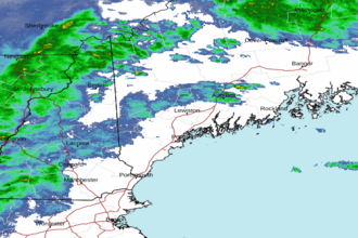 Portland ME Radar
 Northeast Radar