Provincetown MA to Chatham MA to Nantucket MA out 20 NM Marine Forecast
| This Afternoon...Ne Winds 10 To 15 Kt With Gusts Up To 20 Kt. Seas 3 To 4 Ft. Wave Detail: E 3 Ft At 12 Seconds And N 2 Ft At 4 Seconds. |
| Tonight...S Winds Around 5 Kt, Becoming Nw After Midnight. Seas 3 To 4 Ft. Wave Detail: E 4 Ft At 11 Seconds And S 2 Ft At 5 Seconds. |
| Tue...E Winds 5 To 10 Kt. Seas 2 To 4 Ft. Wave Detail: E 3 Ft At 10 Seconds And Se 2 Ft At 5 Seconds. |
| Tue Night...Se Winds 5 To 10 Kt. Seas 2 To 3 Ft. Wave Detail: Ne 3 Ft At 9 Seconds And Se 2 Ft At 5 Seconds. A Chance Of Showers. |
| Wed...Ne Winds 5 To 10 Kt. Seas 2 To 3 Ft. Wave Detail: Ne 3 Ft At 5 Seconds And E 3 Ft At 10 Seconds. A Chance Of Showers. |
| Wed Night...Ne Winds 5 To 10 Kt. Seas 2 To 3 Ft. Wave Detail: E 3 Ft At 5 Seconds And E 2 Ft At 12 Seconds. |
| Thu Through Fri Night...Ne Winds 10 To 15 Kt With Gusts Up To 20 Kt. Seas 2 To 3 Ft. Seas Are Reported As Significant Wave Height, Which Is The Average Of The Highest Third Of The Waves. Individual Wave Heights May Be More Than Twice The Significant Wave Height. |
| Area Forecast Discussion National Weather Service Boston/Norton MA 310pm EDT Monday April 29 2024 Synopsis A backdoor cold front will bring much cooler conditions, clouds, and spot showers tonight and Tuesday morning. Unsettled mid to late in the week due to a backdoor cold front nearby. This could bring spotty showers and keep us a bit cooler, but there is a significant amount of uncertainty with the fronts location. Better shot for more widespread showers late Saturday into Sunday as a frontal system slides through. Near Term - Until 6am Tuesday Morning Backdoor front across SNE will move south and west of the region by early this evening with cooler airmass continuing to advect into the region. The front will stall to the west across eastern NY and while there will be no surface instability, the cool air is relatively shallow and higher 850 mb theta-e air will support marginal elevated instability in western New England tonight. Expect a few showers developing in western MA and northern CT in the vicinity of the low level boundary, and can't rule out an isolated t-storm given MUCAPES 200-500 J/kg. Lows will be mostly in the 40s, but close to 50 in the CT valley. Short Term - 6am Tuesday Morning Through Tuesday Night Tuesday... We may see a few lingering showers across the interior in the morning and perhaps an isolated t-storm in western MA and northern CT, otherwise it should be a mainly dry day as somewhat drier air advects in from the SW. However, plenty of low level moisture in place with easterly BL flow will result in lots of clouds. Much cooler day with highs generally in the 50s, ranging from around 50 across east coastal MA to perhaps the lower 60s in the lower CT valley from Hartford to Springfield. Tuesday night... Mid level shortwave will move across New England Tuesday evening and will likely result in a period of showers as weakening convection moves in from the west. CAMs are rather active with showers and storms developing across central and eastern NY Tuesday afternoon which will weaken as they move into stable environment in SNE during Tuesday night. Otherwise, moist boundary layer will support stratus and perhaps some patchy fog. Lows will be in the 40s. Long Term - Wednesday Through Monday Highlights * Low confidence in the extended with a frontal boundary lingering nearby Wednesday through Fri. Generally think it will be dry, but light spotty showers cannot be ruled out. Temps near to below normal. * Unsettled, especially late this weekend as a frontal system slides in. This brings a better shot for heavier showers. Wednesday through Friday... Mostly will have ridging in place to our west through much of this timeframe. Initially starting off with a shortwave ridge over the eastern Great Lakes early on Fri. The ridge builds into Northern New England, while another ridge builds into the OH Valley/Great Lakes region by Wednesday night. The second ridge over the OH Valley/Great Lakes builds into the eastern Great Lakes on Thu, but a shortwave slides across Quebec into northern New England late on Thu. The ridge continues to build over the eastern Great Lakes/Mid Atlantic on Fri, while the trough digs across the Gulf of ME/Nova Scotia. A frontal boundary will be nearby/over the region through the vast majority of this timeframe. Confidence in the forecast quite low at this point in time given the details are mostly in the mesoscale. The exact location of the front will be key in determining precipitation chances along with temps we realize. Leaned heavily on probabilistic guidance at this point where the GEFS/EPS and GEPS guidance indicate mod to high (40-90%+) probs of precipitation at or above 0.01 inches. The best chance is on Wednesday with essentially 100% probs. Probs are lower at 40-70% on Thu/Fri where the high may be more overhead, but am leery to jump on it being dry with a front nearby/sliding through. Deterministic guidance also a bit all over the place, but shows the best shot on Thu as that shortwave is sliding through. Uncertain, so have stuck with the NBM at this point. Due to uncertainty with the position of the front have also stuck with the NBM for temperatures through this period. If we can get into westerly flow temps could climb into the 70s, especially across the interior on Thu. The GEPS/GEFS/EPS guidance are low to mod (10- 50 % chance) of temps at or above 70 degrees on Wed-Fri. Best shot is across the interior on Thu with little to no shot on Wed/Fri. Saturday through Sunday... Ridge axis in place over the eastern Great Lakes/Upstate NY on Sat. Will have a the ridge building offshore on Sun. During this timeframe a shortwave may ride the ridge later on Sat into Sun. A deeper trough may lift in later on Sun, but there is a lot of uncertainty in its timing/intensity and placement. Appears that it could be drier for a good part of Sat before the frontal system works its way in from the west into Sun. At this point think that Sat could be dry with the showers returning Sun, but just too much uncertainty given not sure how things will evolve even in the previous period. Should note that PWATs (Precipitable Waters) are elevated for the BOX area per NAEFS/EPS situational awareness tables. Values are around 1-1.5 STD above model climo. This in combination with the frontal system sliding through could bring some heavier showers. Again have stuck with the NBM for now. Temperatures will be near to below seasonable. Marine Forecaster Confidence Levels: Low - less than 30 percent. Medium - 30 to 60 percent. High - greater than 60 percent. Through Tuesday night... High confidence. Easterly flow develops tonight and continues into Tuesday night with speeds 10-15 kt and gusts to 20 kt at times. Seas below SCA (Small Craft Advisory) thresholds. Outlook /Wednesday through Saturday/... Wednesday: Winds less than 25 kt. Chance of rain showers. Wednesday Night through Friday: Winds less than 25 kt. Slight chance of rain showers. Friday Night through Saturday: Winds less than 25 kt. Chance of rain showers. NOAA Boston MA Office: Watches - Warnings - Advisories CT...None. MA...None. RI...None. Marine None. |
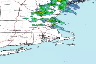 Boston MA Radar
 Northeast Radar
 East Coast Satellite