Albemarle Sound Marine Forecast
| Tonight...Sw Winds 10 To 15 Kt. Waves 1 Ft Or Less, Then Around 2 Ft After Midnight. A Slight Chance Of Showers And Tstms Early This Evening. A Chance Of Showers And Tstms Late This Evening, Then A Slight Chance Of Showers And Tstms After Midnight. |
| Thu...Sw Winds 10 To 15 Kt. Waves 1 Ft Or Less, Then Around 2 Ft In The Afternoon. A Chance Of Showers And Tstms In The Morning, Then Showers And Tstms Likely In The Afternoon. |
| Thu Night...Sw Winds 10 To 15 Kt. Waves Around 2 Ft. Showers And Tstms Likely, Mainly In The Evening. |
| Fri...W Winds 10 To 15 Kt, Increasing To 15 To 20 Kt With Gusts Up To 25 Kt In The Afternoon. Waves Around 2 Ft. A Slight Chance Of Showers In The Morning, Then A Chance Of Showers With A Slight Chance Of Tstms In The Afternoon. |
| Fri Night...Nw Winds 15 To 20 Kt. Gusts Up To 25 Kt In The Evening. Waves Around 2 Ft. A Slight Chance Of Tstms In The Evening. A Chance Of Showers. |
| Sat...N Winds 10 To 15 Kt, Becoming Ne 5 To 10 Kt In The Afternoon. Waves Around 2 Ft In The Morning, Then 1 Ft. |
| Sat Night...Se Winds 5 To 10 Kt, Becoming Sw After Midnight. Waves 1 Ft Or Less. |
| Sun...Nw Winds 10 To 15 Kt. Waves 1 Ft Or Less. |
| Sun Night...N Winds Around 10 Kt. Waves 1 Ft Or Less. |
| Mon...Ne Winds 5 To 10 Kt, Becoming E In The Afternoon. Waves 1 Ft Or Less. |
| Mon Night...Se Winds Around 10 Kt. Waves 1 Ft Or Less. Winds And Waves Higher In And Near Tstms. |
| Area Forecast Discussion National Weather Service Wakefield VA Issued by National Weather Service Newport/Morehead City NC 325pm EDT Wednesday May 8 2024 Synopsis Summer-like conditions with daily showers and storms are expected through Thursday, with a cold front expected to push through the region late Thursday through Friday. An upper level trough will keep a chance for showers late Saturday into Sunday, with dry conditions expected Monday. Near Term - Through Tonight As of 2:30pm Wed...Diurnal cu has developed across the CWA (County Warning Area) but only some light returns on radar have been observed so far today. Surface analysis shows a west/east oriented stationary boundary across TN as well as lee troughing across VA and the Piedmont. The environment is primed to support strong to severe storms with latest RAP analysis showing 1000-2000 J/kg MLCAPE and 45+ kt of deep layer shear. The lacking ingredient for the next few hours, however, is forcing. CAMs are showing clusters of storms developing this evening and moving southeast. Any of these storms could become strong to severe with the main concerns being severe gusts and hail. We'll have a break in the showers and storms is late tonight but Probability of Precipitation will increase again as we get closer to sunrise as a decaying MCS (Mesoscale Convective System, a complex of thunderstorms which becomes organized on a scale larger than the individual thunderstorms) approaches from the west. Short Term - Thursday and Thursday Night As of 3pm Wed...The remnants of a decaying MCS will move through the area Thursday morning and produce scattered showers and storms. The threat for storms to become strong to severe remains on the table, mainly south of I64, given 1000+ J/kg MLCAPE, 45-50 kt of deep layer shear, and mid-level lapse rates slightly greater than 7 C/km. Storm Prediction Center has the entire CWA under a Slight Risk (2/5) for severe weather with the main hazard of concern being damaging wind gusts. Probability of Precipitation will then start to die off as we approach the evening hours. Highs will reach nearly 90 across the southern half of the FA with the northern half remaining closer to 80. Long Term - Friday Through Tuesday As of 315pm EDT Wednesday... There remains some uncertainty for the weekend, but overall the model agreement is improved compared to yesterday's 12Z runs. The main weather maker will be yet another shortwave dropping SE and pushing across the mid Atlantic late Sat through Sunday. This pattern favors increasing clouds Sat afternoon, with low chance Probability of Precipitation pushing into the NW by late afternoon, spreading through the region Sat night/early Sunday. The airmass will be cooler and fairly dry so not expecting much Quantitative Precipitation Forecast with this system (unless the trough and shortwave were to push farther S than any of the guidance currently shows). Will keep ~30% Probability of Precipitation over the N Sat night into early Sunday, with Probability of Precipitation only ~10% in NC. The models start to differ more on Sunday, with the deterministic ECMWF (European Centre for Medium-Range Weather Forecasts) the southern outlier regarding the track of the upper trough. The NBM as well as the GFS (Global Forecast System) and Canadian are drier so will only keep Probability of Precipitation around 20% through Sunday afternoon over the north. It looks dry from late Sunday through midday Tuesday with some low chance Probability of Precipitation possible by later Tuesday as the next upper trough approaches from the lower MS/TN Valley. Temps will be near to slightly below normal Sat-Sunday (highs upper 60s to mid 70s), warming a bit by Mon-Tuesday (highs mid/upper 70s). Marine As of 3pm Wed...The main feature of note during the period will be the chance for strong to severe thunderstorms this evening through tomorrow morning. Winds will generally be 10-15 kt out of the southwest until tomorrow afternoon when they start to back to the east. Waves will be 1-3 ft through the period. Tides / Coastal Flooding As of 315pm EDT Wednesday... A combination of high astronomical and flood tides at the mouth of the bay will lead to areas of nuisance to minor coastal flooding on tonight's high tide cycle. Water levels along bay- facing portions of the MD Eastern Shore will approach or exceed minor flood thresholds tonight and a Coastal Flood Advisory remains in effort for these areas. Locations along and adjacent to the tidal Potomac (Lewisetta/Windmill Pt) will approach but fall short of minor flood thresholds. Therefore, a Coastal Flood Statement has been issued for these areas late tonight. Elsewhere, nuisance tidal flooding is possible but not expected to be impactful enough for additional statements. Climate Record highs for today May 8th: * RIC: 92 (1936) * ORF: 95 (1880) * SBY: 93 (1936) * ECG: 91 (2010) NOAA Wakefield VA Office: Watches - Warnings - Advisories MD...Coastal Flood Advisory from 10pm this evening to 7am EDT Thursday for MDZ021>023. NC...None. VA...None. Marine None. |
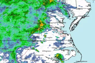 Wakefield Norfolk VA Radar
 Northeast Radar
 East Coast Satellite