Baffin Bay to Port Mansfield, TX Marine Forecast
| Rest Of Today...Southeast Winds 10 To 15 Knots. Seas 4 To 5 Feet. Wave Detail: South 5 Feet At 5 Seconds. Patchy Fog Late This Morning. |
| Tonight...South Winds 10 To 15 Knots. Seas 3 To 5 Feet. Wave Detail: South 5 Feet At 5 Seconds. Patchy Fog After Midnight. |
| Thursday...Southeast Winds 10 To 15 Knots. Seas 3 To 5 Feet. Wave Detail: Southeast 5 Feet At 4 Seconds. Patchy Fog Early In The Morning. |
| Thursday Night...Southeast Winds 10 To 15 Knots, Diminishing To 5 To 10 Knots Early In The Morning. Seas 3 To 4 Feet. Wave Detail: Southeast 4 Feet At 4 Seconds. |
| Friday...East Winds 5 To 10 Knots, Becoming Northeast 10 To 15 Knots In The Afternoon. Seas 3 To 5 Feet. Wave Detail: Northeast 4 Feet At 4 Seconds. |
| Friday Night...Northeast Winds 15 To 20 Knots, Becoming East 10 To 15 Knots In The Late Evening And Overnight. Seas 3 To 5 Feet. Wave Detail: Northeast 4 Feet At 5 Seconds. A Slight Chance Of Showers After Midnight. A Slight Chance Of Showers And Thunderstorms Early In The Morning. |
| Saturday...East Winds 10 To 15 Knots. Seas 4 To 5 Feet. A Slight Chance Of Showers And Thunderstorms. |
| Saturday Night...East Winds 10 To 15 Knots, Becoming Southeast Early In The Morning. Seas 3 To 4 Feet. A Slight Chance Of Showers And Thunderstorms. |
| Sunday...Southeast Winds 10 To 15 Knots. Seas 3 To 4 Feet. A Slight Chance Of Showers And Thunderstorms. |
| Sunday Night...Southeast Winds 10 To 15 Knots. Seas 3 To 4 Feet. A Slight Chance Of Showers And Thunderstorms Early In The Evening. Winds And Seas Higher In And Near Thunderstorms. |
| Area Forecast Discussion ...UPDATED National Weather Service Brownsville TX 1224pm CDT Wednesday May 8 2024 Long Term (Thursday night through Tuesday) Issued at 319am CDT Wednesday May 8 2024 A weak cold front across the Hill Country Thursday evening is expected to push southward and move into Deep South Texas late Thursday night into Friday morning. In the wake of the front, more seasonal temperatures are expected Friday and into the weekend. Daytime high temperatures will be in the upper 80s to low 90s Friday into Sunday. Overnight lows Friday and Saturday night are expected to be in the low to mid 70s. Light east to southeast winds Thursday night will become northeast on Friday with the frontal passage. Easterly winds Saturday and Saturday night are expected to become southeasterly on Sunday as the boundary retreats northward as a warm front and lingers across the area. Abundant moisture combined increased forcing and ample instability could support a slight chance for showers and thunderstorms along the weak cold front Friday. Additional, weak overrunning will support isolated to scattered showers and thunderstorms across the area on Saturday. Onshore flow with increased moisture and instability could again support a slight chance of showers and thunderstorms Sunday and Monday. Temperatures gradually warm through the middle of next week. Marine Issued at 319am CDT Wednesday May 8 2024 Today through Thursday...Generally favorable marine conditions will prevail with light to moderate southeast winds and moderate seas. Brief periods of Small Craft Exercise Caution conditions will be possible each afternoon, especially across the Laguna Madre and northern Gulf waters as the pressure gradient tightens. Thursday night through Tuesday...Light to moderate winds and moderate seas are likely Thursday night. Stronger northeasterly winds will develop behind a cold front Friday will likely require Small Craft Exercise Caution or Small Craft Advisories by Friday afternoon. Winds are expected to diminish Friday night as high pressure settles across the region. Light to moderate winds and moderate seas will prevail along the Lower Texas through the rest of the period. NOAA Brownsville TX Office: Watches - Warnings - Advisories TX... Heat Advisory until 7pm CDT this evening for TXZ250-251-253>255- 353. GM...None. |
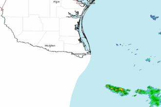 Brownsville TX Radar
 Gulf Radar