Bays and Waterways from Baffin Bay to Port Aransas Marine Forecast
| Rest Of Today...Southeast Wind 5 To 10 Knots. Bays Smooth. |
| Tonight...Southeast Wind Around 10 Knots Shifting South After Midnight. Bays Slightly Choppy To Occasionally Choppy. A Slight Chance Of Showers And Thunderstorms In The Evening. Patchy Fog In The Evening. Areas Of Fog After Midnight. |
| Wednesday...Southwest Wind 10 To 15 Knots Becoming North 15 To 20 Knots In The Afternoon. Bays Choppy To Occasionally Rough. Patchy Fog In The Morning. |
| Wednesday Night...North Wind 20 To 25 Knots. Bays Choppy To Rough. |
| Thursday...Northeast Wind 15 To 20 Knots. Bays Choppy To Occasionally Rough. |
| Thursday Night...Northeast Wind 10 To 15 Knots. Bays Slightly Choppy To Occasionally Choppy. |
| Friday...North Wind 10 To 15 Knots Shifting Southeast In The Afternoon. Bays Slightly Choppy To Occasionally Choppy. |
| Friday Night...Southeast Wind 15 To 20 Knots Becoming South 10 To 15 Knots After Midnight. Bays Choppy. |
| Saturday...South Wind 10 To 15 Knots Becoming Southeast 15 To 20 Knots In The Afternoon. Bays Choppy. |
| Saturday Night...Southeast Wind Around 20 Knots. Bays Choppy To Occasionally Rough. |
| Area Forecast Discussion National Weather Service Corpus Christi TX 249pm CDT Wednesday May 8 2024 ...New SHORT TERM, LONG TER Marine .SHORT TERM... (Tonight through Thursday night) Issued at 218pm CDT Wednesday May 8 2024 Key Messages: ▶ Moderate to Major risk of heat-related impacts, Heat Advisory in effect for inland Nueces and inland Kleberg Thursday ▶ Haze from near-surface smoke lingers and worsens outdoor exposure health risk A weak dryline is currently located right along the Rio Grande up to Del Rio and northeastward. This is expected to move into the Brush Country over the next couple of hours, reducing humidity out west. The greatest heat index values are still expected over the southern Coastal Bend including inland Nueces, inland Kleberg, and Jim Wells Counties. There's still a few hours of heating potential left in breaks of clouds in combination of dewpoints near 80 to cause heat index values of 110. Therefore, will maintain the Heat Advisory through 7pm this evening. Haze has been observed across all of South Texas through the day today and will continue through Thursday night. Smoke guidance from the HRRR (High-Resolution Rapid Refresh) shows increased near-surface smoke concentration advecting from Central America up to South Texas. Weakening winds with high dewpoints will also lead to a threat of patchy fog in combination with the haze. Lows tonight will flirt around the record high minimum values for the 7th day in a row. Although the dryline retreats northwestward tonight, it will push back through most of the Brush Country on Thursday and force clouds to be focused right along the coast to the Victoria Crossroads in the afternoon. The dryline will allow air temperatures to climb around 105-108 over the Brush Country. How high the heat index values get to Thursday will be dependent on the eastward extent of the dryline. As of now, it is expected to halt just west of inland Kleberg and inland Nueces counties, resulting in a medium chance of at least 110 heat indices in the afternoon. Therefore, have issued a Heat Advisory for those two county portions from 1-7pm Thursday. Long Term (Friday through next Tuesday) Issued at 218pm CDT Wednesday May 8 2024 Key Messages: ▶ Weak cold front Friday morning ▶ Rain chances return this weekend Models are beginning to come into better agreement showing a weak cold front pushing through the region Friday morning providing some relief from the recent above normal temperatures. While rain chances are low with the cold front, rain chances will increase Saturday as the front retreats northward as a warm front ushering in PWAT (Precipitable Water) between 2.0-2.1". Low end chances (20% or less) for rain Saturday will increase to a medium (30-55%) chance Sunday and Monday as a shortwave moves across the region interacting with the abundant moisture. While the Victoria Crossroads appears to be the early favorite for the best chances of rain, the whole county warning area will be in play especially Monday, when models show a surface low moving across the area. Rain chances will quickly taper off early next week as we begin to dry out. Temperatures in the wake of the front will drop into the 80s Friday afternoon and Saturday with most of the region in the lower to upper 80s. Temperatures will begin to increase once again Sunday before climbing back into the lower to upper 90s early next week into mid- week. Lows throughout the long term period are expected to remain steady in the lower to mid 70s. Marine Issued at 218pm CDT Wednesday May 8 2024 Weak to moderate onshore winds can be expected through Thursday night along with patchy fog in the late night and early morning hours. In addition to patchy fog, haze from near-surface smoke southward will likely continue before our next front passes. A cold front will move offshore Friday morning. Weak to moderate northeast winds Friday will strengthen to moderate to strong Saturday as it shifts to the east. By early next week, winds will shift to the southeast and remain moderate. Rain chances return Saturday with a low chance and increases to a medium chance Sunday and Monday. NOAA Corpus Christi TX Office: Watches - Warnings - Advisories TX... Heat Advisory until 7pm CDT this evening for TXZ241>243. Heat Advisory from 1pm to 7pm CDT Thursday for TXZ242-243. GM...None. |
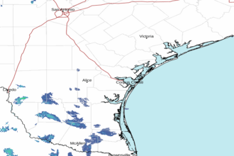 Corpus Christi TX Radar
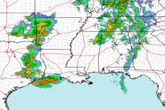 Gulf Radar