Buzzards Bay Marine Forecast
| Overnight...W Winds 5 To 10 Kt. Seas Around 2 Ft. Wave Detail: Sw 1 Foot At 5 Seconds And E 1 Foot At 10 Seconds. Patchy Fog. A Chance Of Showers With A Slight Chance Of Tstms. Vsby 1 Nm Or Less. |
| Thu...Nw Winds 5 To 10 Kt, Becoming Ne In The Afternoon. Seas Around 2 Ft. Wave Detail: Sw 1 Foot At 5 Seconds And E 1 Foot At 10 Seconds. Patchy Fog In The Morning. A Chance Of Showers In The Afternoon. |
| Thu Night...Ne Winds 10 To 15 Kt With Gusts Up To 20 Kt. Seas Around 2 Ft. Wave Detail: Ne 2 Ft At 3 Seconds And Sw 1 Foot At 5 Seconds. A Chance Of Showers. |
| Fri...Ne Winds 15 To 20 Kt With Gusts Up To 25 Kt. Seas 2 To 4 Ft. Wave Detail: Ne 2 Ft At 3 Seconds And S 1 Foot At 7 Seconds. A Chance Of Showers. |
| Fri Night Through Sat Night...Ne Winds 15 To 20 Kt. Seas 2 To 3 Ft. Wave Detail: Ne 2 Ft At 3 Seconds And S 1 Foot At 7 Seconds. A Chance Of Showers. |
| Sun And Sun Night...E Winds Around 10 Kt, Becoming Sw. Seas Around 2 Ft. Wave Detail: E 2 Ft At 4 Seconds And Sw 1 Foot At 8 Seconds. A Chance Of Showers. |
| Mon And Mon Night...Sw Winds 10 To 15 Kt With Gusts Up To 20 Kt. Seas Around 2 Ft. Winds And Seas Higher In And Near Tstms. Seas Are Reported As Significant Wave Height, Which Is The Average Of The Highest Third Of The Waves. Individual Wave Heights May Be More Than Twice The Significant Wave Height. |
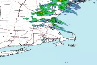
| Area Forecast Discussion National Weather Service Boston/Norton MA 1008pm EDT Wednesday May 8 2024 Synopsis Another round of scattered showers and thunderstorms will move across the region this afternoon and this evening. Periods of unsettled weather continue late this week into this weekend with showers at times. Temperatures will average below normal late this week into the weekend. Milder/Seasonable temperatures should return early next week. Near Term - Through Thursday 10 PM Showers and scattered t-storms will be exiting the Cape/Islands during the next hour or so as the mid level shortwave moves to the east. Subsidence and drying behind the shortwave will result in dry conditions overnight. However, stratus and fog will linger into the overnight across eastern MA and Cape/Islands before clearing toward daybreak. Lows will be in the upper 40s and lower 50s. .SHORT TERM /THURSDAY NIGHT THROUGH 6pm THURSDAY/... Thursday starts out dry as a wedge of dry air remains in place over SNE. Moisture increases from the SW during the afternoon ahead of next shortwave dropping through the Great Lakes and OH valley, with low pressure moving to mid Atlantic region. Risk of showers will increase during the afternoon. Highs should be mostly in the 60s, mildest CT valley and coolest along the coast in eastern MA where developing NE flow will likely hold temps in the upper 50s here. These showers will continue into Thursday night. With cloud cover and rain, temperatures across much of the area will remain in the middle and upper 40s. Long Term - Thursday Night Through Sunday Key Points... * More widespread rain possible Friday into Saturday night * Below average temperatures continue through the weekend * More seasonable temps return next week Friday A shortwave trough exits out of the Ohio River Valley becoming negatively tilted as it moves over SNE. The surface low is initially vertically stacked with the shortwave aloft and begins to occlude as new low forms and intensifies offshore to the east. Although the best forcing will be to the south of SNE, the chances for a widespread rain are increasing. As a mid level low passes over and intensifies to the south of the region, this will drag down rather cold 850mb air around 0C to -2C. With ENE winds at the surface, along with cold 850mb temps, low clouds, and rain, high temps may struggle to even reach 50F across the region. Rain looks to continue into Friday night before tapering off Saturday morning. Overnight lows look to drop into the low 40s, with upper 30s possible in the high terrain. Not out of the question that snow mixes in with rain across the high terrain in the Berkshires. Saturday Surface and midlevel low move well out to sea bringing widespread rain to end in the morning. However, an upper level closed low drops south over the region leaving SNE under cyclonic flow aloft. With weak forcing aloft and the mid level cold pool(a region of relatively cold air) still in place, this will likely lead to a hit or miss light showers/drizzle. High temps on Saturday don't look to recover much with thick low level cloud layer still around. High temps should only reach the low to mid 50s with continued onshore flow. Sunday Another weak surface low exits the Ohio River Valley and passes just south of SNE. This could bring another round of widespread light rain to the region. Uncertainty with this system remains high given the weak upper level forcing and not much run to run consistency on the track of the low. Highs remain below normal Sunday and could once again struggle to reach 50F. Next week The pesky upper level low and mid level cold pool(a region of relatively cold air) finally move east as a midlevel shortwave brings WAA (Warm Air Advection - the movement of warm air) and 850mb temps above 0C to even +10C by mid week. This will allow high temps to moderate back into the low to mid 70s. As for rain chances, high pressure to the south should keep things dry early in the week. Rain chances look to increase again mid to late week, but uncertainty is high at this time. Marine Forecaster Confidence Levels: Low - less than 30 percent. Medium - 30 to 60 percent. High - greater than 60 percent. Through Thursday...High confidence. Low level jet will bring a period of SW gusts to 20+ kt to south coastal waters this afternoon and evening. Winds diminish tonight, becoming north by Thu morning then NE 10-20 kt during Thu afternoon. Seas remain below SCA (Small Craft Advisory) thresholds. Areas of fog will reduce visibilities at times over south coastal waters through tonight. Scattered showers and embedded t-storms move through this morning into early afternoon. Outlook /Thursday Night through Monday/... Thursday Night: Winds less than 25 kt. Areas of seas approaching 5 ft. Chance of rain showers. Friday through Friday Night: Winds less than 25 kt. Seas up to 5 ft. Slight chance of rain. Saturday: Winds less than 25 kt. Seas up to 5 ft. Saturday Night: Winds less than 25 kt. Areas of seas approaching 5 ft. Sunday: Winds less than 25 kt. Areas of seas approaching 5 ft. Slight chance of rain. Tides / Coastal Flooding High astronomical tides coupled with onshore flow may result in some splashover/very minor coastal flooding during the overnight high tide cycles tonight and Fri night. However, wind/waves do not appear high enough to result in a significant issue. The daytime high tides are lower and do not pose a threat for coastal flooding. NOAA Boston MA Office: Watches - Warnings - Advisories CT...None. MA...None. RI...None. Marine None. |
 Boston MA Radar
 Northeast Radar
 East Coast Satellite