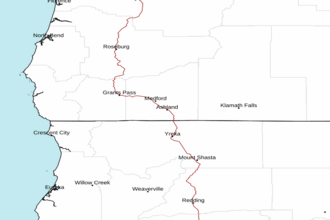
Cape Blanco OR to Point St. George CA out 10 NM Marine Forecast
| Tonight...Nw Gales 35 Kt...Becoming N 20 To 25 Kt. Within 5 Nm Of Brookings Southward, Nw Wind 30 Kt...Easing To 10 To 20 Kt. Combined Seas 9 To 12 Ft Dominant Period 12 Seconds In The Evening. |
| Thu...N Wind 15 Kt...Backing To Nw 20 To 25 Kt In The Afternoon. Within 5 Nm Of Brookings Southward, Nw Wind 15 To 25 Kt...Easing To 10 To 20 Kt In The Afternoon. Wind Waves N 6 Ft At 7 Seconds. Swell Nw 3 To 5 Ft At 11 Seconds. |
| Thu Night...N Wind 15 To 20 Kt...Becoming Ne 5 Kt After Midnight, Then...Veering To E Early In The Morning. Within 5 Nm Of Brookings Southward, Nw Wind 10 To 15 Kt...Veering To N 5 Kt Late In The Evening, Then... Veering To Ne After Midnight. Wind Waves Nw 6 Ft At 7 Seconds. Swell Nw 4 To 5 Ft At 11 Seconds. |
| Fri...Ne Wind 5 Kt...Backing To Nw In The Afternoon. Wind Waves Nw 3 Ft At 7 Seconds. Swell Nw 5 Ft At 11 Seconds. |
| Fri Night...N Wind 5 To 10 Kt. Wind Waves Nw 2 Ft At 6 Seconds. Swell Nw 4 To 5 Ft At 11 Seconds. |
| Sat...N Wind 5 To 10 Kt...Backing To Nw In The Afternoon. Wind Waves Nw 3 Ft At 6 Seconds. Swell Nw 3 To 4 Ft At 11 Seconds. |
| Sat Night...N Wind 10 To 15 Kt. Wind Waves Nw 4 Ft At 6 Seconds. Swell W 2 To 3 Ft At 10 Seconds. |
| Sun...N Wind 15 Kt...Rising To 25 Kt In The Evening, Then... Easing To 20 Kt After Midnight. Wind Waves N 4 Ft At 6 Seconds. Swell W 2 To 3 Ft At 9 Seconds And Sw 2 Ft At 15 Seconds. |
| Mon...N Wind 20 Kt...Rising To 25 Kt. Wind Waves N 6 Ft At 7 Seconds. Swell Nw 3 To 4 Ft At 13 Seconds And Sw 2 Ft At 15 Seconds. |
| Area Forecast Discussion National Weather Service Medford OR 909am PDT Wednesday May 8 2024 Made some minor updates to the forecast for this morning. First was to cancel the Freeze Warning early. Freezing temperatures were observed in portions of the Shasta/Scott/Applegate Valleys, but for areas in the Illinois Valley, gusty east to northeast winds kept temperatures elevated overnight. Some freezing temperatures were also observed in the outskirts of Jackson County, but temperatures have already risen this morning, so the Freeze Warning was cancelled early. There is some lingering cloud cover in the Umpqua Basin and across portions of Lake County, but this will gradually dissipate over the next few hours leading to sunny skies across the region this afternoon. Temperatures will trend warmer today under strengthening high pressure aloft and a strengthening thermal trough at the surface. Temperatures will be about 10 degrees warmer today compared to recent days, nearing values more typical for this time of year. Expect some gusty north to northeast winds today under this pattern, and the Chetco Effect will bring some warmer temperatures to the Brookings area this afternoon (low to mid 70s). Forecast updates included tweaking temperatures by a few degrees for this afternoon as well as nudging winds towards the latest guidance. While temperatures will be near normal values today (upper 60s/low 70s west of Cascades, upper 50s/low 60s east), this will be last day through at least early next week for near normal temperatures. A sharp warm up is in store for Thursday into the weekend with high temperatures reaching 10 to 15 degrees above normal. For more details on this, please see the previous discussion below. /BR-y /Issued 852am PDT Wednesday May 8 2024/ Updated Marine Discussion. Marine Updated 845am Wednesday, May 8, 2024...A strong thermal trough will persist through tonight. This will result in moderate to strong winds, with winds strongest south of Cape Blanco with gales and very steep seas. Winds will increase north of Cape Blanco later this afternoon into tonight. Wind speeds should remain on the high end of Small Craft, however very steep wind driven seas will result in Hazardous Seas Warning conditions for the all of the northern waters. The thermal trough will weaken Thursday, but lingering steep to very steep seas are possible. Lighter winds and seas expected Friday into the weekend. -Petrucelli Temperatures aren't dropping much this morning as dewpoints stay in the mid 30's across a lot of valleys west of the Cascades. The exception appears to be the Scott Valley with temperatures currently around 32 to 34 with dewpoints in the upper 20's. Other than the patchy freezing conditions across the forecast area this morning, concerns are minimal given the current temperatures. High temperatures will trend about 10 to 15 degrees higher today compared to Tuesday as high pressure continues to build over southern Oregon and northern California. A thermal trough will strengthen along the southern Oregon coastline this morning with some north east flow developing along the coastal range. Brookings and Somes Bar in south western Siskiyou County will be the warm spots later today with both pushing into mid 70's with Somes Bar potentially hitting the 80's. Overall, this is pretty typical for temperatures this time of year as Medford's average high is 72. Temperatures will continue to trend warmer by Thursday as high pressure strengthens off the coast and winds becomes more widespread out of the east. This should result in further bump in temperatures with the most notable jump around Roseburg and North Bend with an anticipated high of 83 and 75 degrees respectively on Thursday. This warm up will push highs well above their normals for this time of year. The thermal trough will move farther inland on Friday with sea level pressure dropping about 10 mb east of the Cascades and the 1000-500 mb thickness' rising over locations farther to the east as well. These days are usually some pretty warm days and the temperature forecast shows this with some highs potentially hitting 90 degrees. The NBM gives Medford a 15% chance of hitting 90 and Roseburg a 40% chance of hitting 90 on Friday. Not much will change on Saturday, although the temperatures might trend down a degree or two. It's worth noting that the NWS' heat risk algorithm is showing an elevated heat risk for populated areas on Saturday, perhaps due to the unusually warm high temperatures for this time of year. Given that low temperatures are falling into the mid 50's, this elevated risk seems overdone. Towards the start of next week, the NBM is predicting a 5% chance of precipitation across sections of northern California as a weak short wave could be moving through around Sunday evening or Monday evening. To elevate the thunderstorm threat, we pushed the probability of precipitation higher for those times. Any shortwave this time of year will have that threat of kicking off thunderstorms around the forecast area. Towards the middle of next week it appears high pressure will still remains in control. Temperatures have a higher probability being warmer than normal versus cooler than normal for the middle of May. -Smith NOAA Medford OR Office: Watches - Warnings - Advisories OR...CA...None. PACIFIC COASTAL WATERS...Small Craft Advisory until 2pm PDT this afternoon for PZZ350-356-370-376. Hazardous Seas Warning from 2pm this afternoon to 5am PDT Thursday for PZZ350-370. Gale Warning until 5am PDT Thursday for PZZ356-376. |
 Medford OR Radar
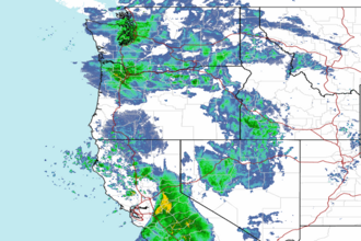 Northwest Radar