Cape Elizabeth ME to Merrimack River MA Marine Forecast
| Today...E Winds 5 To 10 Kt, Increasing To 10 To 15 Kt With Gusts Up To 20 Kt Early This Afternoon, Then Becoming Ne 5 To 10 Kt With Gusts Up To 20 Kt Late. Seas 2 To 3 Ft. Wave Detail: Se 2 Ft At 10 Seconds. A Chance Of Showers This Morning, Then Showers Likely With A Chance Of Tstms This Afternoon. Vsby 1 Nm Or Less Late This Morning, Increasing To 1 To 3 Nm, Decreasing To 1 Nm Or Less Late. |
| Tonight...N Winds 5 To 10 Kt. Seas 2 To 3 Ft. Wave Detail: Se 2 Ft At 5 Seconds And E 2 Ft At 10 Seconds. Patchy Dense Fog In The Evening. Patchy Fog After Midnight. Vsby 1 Nm Or Less. |
| Thu...Ne Winds 5 To 10 Kt. Seas 2 To 3 Ft. Wave Detail: Ne 2 Ft At 3 Seconds And Se 2 Ft At 6 Seconds. Patchy Fog. A Chance Of Showers In The Afternoon. Vsby 1 Nm Or Less, Increasing To 1 To 3 Nm In The Afternoon. |
| Thu Night...Ne Winds 10 To 15 Kt With Gusts Up To 25 Kt. Seas 2 To 3 Ft. Wave Detail: E 3 Ft At 4 Seconds. A Chance Of Showers In The Evening. Patchy Fog In The Evening With Vsby 1 To 3 Nm. |
| Fri...Ne Winds 10 To 15 Kt With Gusts Up To 25 Kt. Seas 3 To 4 Ft. Wave Detail: E 4 Ft At 5 Seconds. A Chance Of Showers In The Afternoon. |
| Fri Night...Ne Winds 5 To 10 Kt. Seas 3 To 4 Ft. Wave Detail: E 4 Ft At 6 Seconds. |
| Sat...Ne Winds 5 To 10 Kt. Seas 3 To 4 Ft. |
| Sat Night...Ne Winds Around 5 Kt, Becoming Sw After Midnight. Seas 3 To 4 Ft. |
| Sun...S Winds 5 To 10 Kt. Seas 3 To 5 Ft. A Chance Of Showers. |
| Sun Night...Se Winds 5 To 10 Kt. Seas 3 To 4 Ft. A Chance Of Showers In The Evening. Winds And Seas Higher In And Near Tstms. |
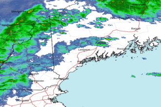
| Area Forecast Discussion National Weather Service Gray ME 1046am EDT Wednesday May 8 2024 Synopsis Several cool and unsettled days are in store as a warm front remains south of most of our forecast area. Widespread showers overspread the region today with some thunder. Another system follows for the end of the week, bringing more showers into the forecast. The unsettled, showery pattern may continue through the weekend and possibly into early next week. Near Term - Until 6pm This Evening 1040 AM...Quick update that better times the POPs today, and adjusted temps on bit to have them start to go down this afternoon in areas between the mtns and the Gulf of ME as the onshore flow improves somewhat. Also, remove thru thunder for the rest of the morning, but reintroduce with next round of showers later this afternoon, best chance will be in S NH. 605 AMNo changes at this time other to add a little more sun to eastern zones for a few more hours before clouds roll in. Showers with a few thunderstorms will reach the CT River in NH between 730 and 830 AM. Previously... Our two day stretch of warm and sunny weather is coming to an end today as a short wave trough approaches from the west and an attendant SFC warm from remains largely to our south. This will mean temperatures a good 15 to 20 degrees colder today. Forcing for ascent will increase this morning across the western zones then quickly overspread the rest of the forecast area during the latter morning and early afternoon hours. Despite cool SFC temperatures, relatively steep lapse rates aloft will aid in at least a few hundred J/KG of elevated CAPE. This should be enough for at least isolated thunder and a few heavy downpours as the showers arrive from the west this morning, mainly across western and southern NH. Elevated instability should remain much of the day across the southern half of the forecast area, offering showers with a few rumbles of thunder from time to time. With that said we do not expect rain all day, in fact several hours during the afternoon could be dry unless the drizzle machine gets going. Another short wave trough arrives to bring another concentrated area of showers later on this afternoon and evening. These could contain some thunder as well. Across the far south, mainly southwestern NH, a storm or two could be on the strong side depending on how much instability is able to develop near (likely just north) of the SFC warm front. Small hail will be possible, maybe with a brief instance of strong SFC convective winds depending on how low level lapse rates pan out. Non-zero chance of a brief weak tornado there if a sustained cell can develop with surface or near-surface based instability. Again, this would most likely be southwestern NH if at all. Short Term - 6pm This Evening Through 6pm Thursday Showers linger into this evening but should see some drying after midnight, as we move to the back side of the low. Could also be fog and drizzle. Lows will be mainly in the 40s. Moist low level onshore flow continues Thursday with colder than normal temperatures and lots of clouds. Forcing for ascent really isn't that great so a lot of the day should be dry other than some fog and drizzle at times, mainly on the coast. Long Term - Thursday Night Through Tuesday Overview: Low pressure will swing out of the Ohio Valley and towards the Northeast Thursday night into Friday. This low remains through Friday night, before phasing with another area of low pressure passing off the East Coast. Broad cyclonic circulation will keep unsettled conditions in the region for the remainder of the weekend and early next week. Details: Guidance has trended further south with moisture associated with incoming low pressure Friday. The important note will be where this low stalls as it transits from the Ohio Valley to the Northeast. High pressure to the north will keep the column from becoming fully saturated across the area, with most of the shower activity confined to southern NH. Can't rule out some isolated showers overnight into early Saturday considering its proximity, and eventual phasing with low pressure moving NE off the East Coast. Quantitative Precipitation Forecast remains on the light side, and have undercut NBM Quantitative Precipitation Forecast in favor of some of the more recent deterministic runs which show the low's center further to the south and west Fri/Fri night. Kept with the trend of cooler interior temperatures Friday, but think some cloud cover may develop breaks towards the ME Midcoast and interior. Kept temps pushing into the upper 50s here, with 60 possible the further NE from precipitation in southern NH. These warm temperatures should be more widespread on Saturday as wave broadens and merges with low pressure moving up the coast. This is just offshore enough to keep chances of widespread rainfall low, but will still likely keep skies cloudy for a bulk of the weekend. Southerly flow returns into early next week, and this should allow more persistent WAA (Warm Air Advection - the movement of warm air) to push temperatures into the 60s and perhaps lower 70s by midweek. There will be the lingering chance of showers into midweek as well. The pattern becomes more open, allowing weak forcing to combine with passing fronts and moisture to bring rain chances almost daily. At this time, confidence in timing and amounts are low, and will be focusing on narrowing those windows in the near/short term. Marine Short Term A brief period of low-end SCA (Small Craft Advisory) gusts possible midday today on the ocean waters, but otherwise, we expected conditions to largely remain below SCA (Small Craft Advisory) thresholds today through Thursday. However, occasional showers and fog are expected over the waters. Long Term Conditions may approach SCA (Small Craft Advisory) criteria Thursday night into Friday, with waves 2 to 4 ft and winds gusting to around 20 kt. This occurs as low pressure spins inland across NY state, and phases with passing low pressure off the New England waters. Broad cyclonic flow will keep unsettled conditions over the waters for much of the weekend. Tides / Coastal Flooding High astronomical tides combined a small of storm surge may push water levels to around minor flood stage around the times of high tide tonight and Thursday night. NOAA Gray/Portland ME Office - Watches - Warnings - Advisories ME...None. NH...None. Marine None. |
 Portland ME Radar
 Northeast Radar