Cape Flattery to James Island WA out 10 to 60 NM Marine Forecast
| Tonight...Nw Wind 5 To 15 Kt. Wind Waves 1 To 2 Ft. Nw Swell 9 Ft At 12 Seconds. |
| Wed...Nw Wind 5 To 15 Kt Becoming 10 To 20 Kt In The Afternoon. Wind Waves 1 To 2 Ft Building To 2 To 4 Ft In The Afternoon. W Swell 6 Ft At 12 Seconds. |
| Wed Night...Nw Wind 15 To 20 Kt Becoming N 5 To 15 Kt After Midnight. Wind Waves 2 To 4 Ft. W Swell 6 Ft At 11 Seconds. |
| Thu...N Wind 5 To 15 Kt. Wind Waves 1 To 2 Ft. W Swell 6 Ft At 10 Seconds. |
| Thu Night...N Wind 5 To 15 Kt. Wind Waves 1 To 2 Ft. W Swell 7 Ft At 11 Seconds. |
| Fri...N Wind 5 To 15 Kt. Wind Waves 1 To 2 Ft. W Swell 6 Ft At 11 Seconds. |
| Fri Night...Nw Wind 5 To 15 Kt Becoming 10 To 20 Kt After Midnight. Wind Waves 1 To 3 Ft. Nw Swell 6 Ft At 10 Seconds. |
| Sat...Nw Wind 10 To 20 Kt Becoming 15 To 20 Kt. Wind Waves 1 To 3 Ft. Nw Swell 3 To 7 Ft Building To 7 To 9 Ft. |
| Sun...Nw Wind 15 To 20 Kt. Wind Waves 1 To 3 Ft. Nw Swell 7 Ft. |
| Area Forecast Discussion National Weather Service Seattle WA 835pm PDT Tuesday May 7 2024 We're in store for benign conditions here this evening. Lingering showers are on track to fizzle out as upper-level ridging builds in. Overnight lows are to fall into the mid 30s to lower 40s. The previous discussion remains below along with an updated marine/aviation section. Synopsis An upper level trough will exit the region today and a ridge of high pressure aloft will begin to build into the area on Wednesday. The upper ridge will strengthen toward the end of the week as thermally induced low pressure near the surface expands northward into the area. Dry conditions will prevail along with the warmest temperatures of the year thus far on Friday and Saturday. A weak system passing to the north of the area will bring a minor cooling trend Sunday into Monday. Short Term - Tonight Through Saturday Scattered showers over much of the area will linger through the afternoon becoming limited to the Cascades the evening. There remains a 15-25% chance of isolated thunder over the Central and South Cascades this evening before showers completely taper out as upper level ridging begins to build into the area overnight. Morning clouds Wednesday morning will give way to sunshine with near normal high temperatures nosing well into the mid 60s. The the offshore upper level ridge will tip further over the region Thursday with thermally induced low pressure expanding northward along the Oregon coast. This will turn the low level flow northerly and offshore, which will help warming along the coastal areas a bit more than the interior. Hoquiam and Forks are expected to warm into the mid 70s (or higher) on Thursday afternoon. Interior areas will warm up as well...with lower to mid 70s common from the Seattle area southward. The upper ridge axis shifts onshore on Friday while the thermal trough remains more or less oriented along the coast. This will likely be the warmest day for the coast...with highs reaching the lower to mid 80s especially along the North Coast...which is daily record territory. In fact, there is a 90% chance of temperatures at or above 80 at Forks on Friday. Elsewhere, sunshine and warm temperatures with similar probabilities for temperatures above 80 across the interior lowlands from the Seattle Metro area southward , including much of the central Kitsap Peninsula. Model guidance continues to hint a a more progressive shift in the pattern Friday night with the ridge axis potentially broadening over much of the Western US and the thermal trough shifting inland. Long Term - Saturday Through Tuesday The shift of the thermally induced surface trough onshore will help onshore flow and cooler temperatures for the Coastal areas with 15 to 20 degrees of cooling for Saturday. Warm temperatures will very likely linger for much of the interior, potentially as warm as Friday especially through the metro area. Onshore flow and a weakening in the ridge on Sunday as a system passes to the north will help temperatures dip into the 60s and 70s - still near or just above normal and dry. Dry and warm spring weather looks to linger into mid week. Marine Winds have eased across the Strait this evening, thus ended the Small Craft Advisory for the West Entrance, with wind gusts still going strong through the central and east Strait. High pressure will build over the waters through Wednesday night. Thermally induced low pressure then will move up the coast on Thursday and shift inland Friday and east of the Cascades later on Saturday. Westerly winds will continue to remain breezy into Wednesday, particularly for the central Strait of Juan de Fuca, with Small Craft Advisory winds during this period, along with adjacent waters. Northerly winds will increase Wednesday afternoon into Wednesday evening, especially for the inner Coastal Waters, where brief SCA (Small Craft Advisory) wind gusts may be possible. North winds then continue into the weekend. Seas of 10 feet will subside to 8 to 9 feet tonight and 6 to 7 feet on Wednesday. Davis/JD Hydrology The daily hydrology discussion has ended until the start of the next rainy season; it will only be updated as needed. NOAA Seattle WA Office: Watches - Warnings - Advisories WA...None. PZ...Small Craft Advisory until 2am PDT Thursday for Central U.S. Waters Strait Of Juan De Fuca. Small Craft Advisory until 8am PDT Wednesday for Admiralty Inlet Coastal Waters From Cape Flattery To James Island 10 To 60 Nm- Coastal Waters From Cape Flattery To James Island Out 10 Nm- Coastal Waters From James Island To Point Grenville 10 To 60 Nm- Coastal Waters From James Island To Point Grenville Out 10 Nm- Coastal Waters From Point Grenville To Cape Shoalwater 10 To 60 Nm- Coastal Waters From Point Grenville To Cape Shoalwater Out 10 Nm- East Entrance U.S. Waters Strait Of Juan De Fuca. |
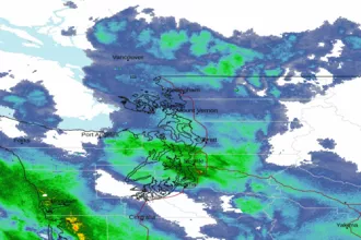 Seattle/Tacoma WA Radar
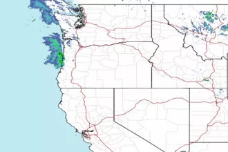 Northwest Radar