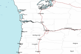
Cascade Head to Florence OR from 10 to 60 NM Marine Forecast
| Rest Of Today...S Wind To 5 Kt. Wind Waves S 1 Ft At 4 Seconds. Nw Swell 3 Ft At 9 Seconds. Widespread Dense Fog In The Morning. Areas Of Dense Fog In The Afternoon. |
| Tonight...N Wind To 5 Kt. Wind Waves N 1 Ft At 4 Seconds. Nw Swell 3 Ft At 9 Seconds. Areas Of Dense Fog In The Evening. Patchy Dense Fog After Midnight. |
| Wed...Ne Wind 5 Kt, Backing To Nw To 5 Kt In The Afternoon. Wind Waves Ne 1 Ft At 4 Seconds, Shifting To The Nw At 4 Seconds In The Afternoon. Nw Swell 3 Ft At 9 Seconds. Patchy Dense Fog In The Morning. |
| Wed Night...Nw Wind 5 Kt, Backing To Se After Midnight. Wind Waves Nw 1 Ft At 4 Seconds, Shifting To The Se At 4 Seconds After Midnight. Nw Swell 3 Ft At 9 Seconds. |
| Thu...S Wind 5 Kt. Wind Waves S 1 Ft At 4 Seconds. Nw Swell 3 Ft At 10 Seconds. |
| Thu Night...N Wind 5 To 10 Kt. Wind Waves N 2 Ft At 4 Seconds. Nw Swell 3 Ft At 10 Seconds. |
| Fri...N Wind 5 To 10 Kt. Wind Waves 2 Ft. Nw Swell 4 Ft. |
| Sat...Nw Wind 5 To 10 Kt. Wind Waves 2 Ft. Nw Swell 4 Ft. |
| Area Forecast Discussion National Weather Service Portland OR 1002am PST Sunday Dec 14 2025 Synopsis A weak front will move over the area today bringing light rain. A pair of quick moving frontal systems associated with subtropical moisture will bring additional rounds of heavier rainfall and river rises on Monday and Tuesday. The probability for exceeding minor flood stage at the majority of rivers remains around 20-25% or less. Breezy to gusty southerly winds are also expected both days with the strongest winds likely Tuesday night. Onshore flow continues with showers on Wednesday. Lowering snow levels will allow for snow to fall at pass level in the Cascades. Precipitation continues through late next week, with potential for another strong system on Thursday. .SHORT TERM...Now through Tuesday Night...Radar imagery shows the frontal system nearing the coast line this morning. Rain associated with this system is expected to have minimal accumulation as the front is decaying as it nears the area. A bulk of the rainfall will be to the north. Overall, rainfall not expected to be impactful. Warm air will linger with highs still well above normal for December. Monday and Tuesday become the stars of the short term forecast as a much stronger slug of subtropical moisture moves in. This moisture is associated with an atmospheric river that has the potential to be quite robust. Lets first start with the driving force of the increased warm system. A closed low sitting in the Gulf of Alaska is quite energetic and is acting almost like a magnet drawing the warm air northward from the tropics. This low will remain nearly stationary through much of the week. Diving in a bit deeper a shortwave trough embedded within the flow of this low will move over the region on Monday. This trough will bring the first round of heavy rain as it's able to tap into the river of warm air aloft. The first system next week will be associated with IVT values peaking around 750-1000 kg/m/s, which would place it in the strong atmospheric river category. But, what makes this different from last week's AR event is both a shorter duration and a more southwest orientated flow. Now location, location, location is going to be one of the main determining factor regarding accumulation of this system. There is a general consensus that we will see heavy rain. However, some slight differences in the area of highest rainfall remains. For example, the GFS (Global Forecast System) has lower rainfall totals than the other global models. Therefore to get a better idea of rainfall totals we will have to dive into the higher resolution models. Accumulation is trending lower than the previous system that caused widespread flooding. However, don't become complacent as there is still a high probably (50-70%) for exceeding 2 inches of rainfall in the higher terrain of SW Washington and the northern Oregon Coast Range, but chances of exceeding 4 inches is less than 10%. The main concern with this pattern remains on rivers that are running high from last week's rainfall. With any strong winter system, wind is a concern. Over the last few days, models have become more and more robust with wind speeds. Southwesterly winds will begin to increase late tonight ahead of the system and persist through the day. Highest wind speeds are expected along the coast but inland locations like the Willamette Valley and lower I-5 corridor in Washington are susceptible to southerly winds. There is greater than a 90% chance of wind gusts of 40 mph or higher along the coast and around a 15% chance in the interior valleys. For gusts greater than 50 mph, there is around a 35-50% chance along the coast with less than a 5% chance inland. One area to watch for those on the mountains is the potential for very strong winds there. There is a 10% chance of gusts as high as 65-75 mph along the Cascades and some of the exposed locations within the foothills. Overall, prepare for a potentially windy Monday. As previously mentioned, Tuesday will bring little reprieve as another trough moves in later in the afternoon and evening. Rainfall totals once again will be high with similar accumulation to Tuesday in southwest Washington. Conditions will be drier in Oregon due to the northerly track of the system. One difference though is the potential for even stronger winds. Recent MSLP models are suggesting a surface mesoscale low pressure system forming near the British Columbia islands. If this low does form then southerly winds will be amplified. There is a 15-25% chance of Wind Advisory speeds (frequent gusts of 45-57 mph) within the interior lowland valleys Tuesday evening and early Wednesday. There is a 10-15% chance of high winds (gusts of 58+ mph) along the coast and Cascade foothills. -27 Long Term Wednesday through Saturday...Snow levels are expected to drop significantly by Wednesday morning with the passage of the upper trough. This will allow for snow to begin accumulating at pass level on Wednesday. The weather setup on Wednesday will feature onshore flow with zonal flow aloft, likely maintaining showers enhanced by orographic effects. There remains quite a large spread of uncertainty for snowfall amounts through Wednesday night. Areas with the probability for the highest snow amounts are within the south Washington Cascades where there is a 50-60% chance of receiving 6+ inches and a 20-30% chance of 12+ inches in 24 hours. To describe that uncertainty even further, the NBM's 10-90th percentile (essentially the driest and wettest scenario) gives a range of 1"-13" at Santiam Pass. The upper end range has decreased from last afternoon which shows the potential for the range to narrow. With that said though, for those preparing to travel, it is critical that you keep an eye on the forecast. As the synoptic pattern progresses into late next week there is a trend for yet another atmospheric river on Thursday into Friday. At this point confidence is quite low as there remains significant inconsistencies between ensembles, individual models, and run-to-run outputs. The Warning Prediction Center (WPC) has increased the risk of excessive rain to a "slight risk" which means there is increasing probability of exceeding flash flooding guidance. Now, that comes down to rain rates and total rain accumulation. As previously stated there remains significant uncertainty. However, it's never to early to be thinking about the impacts of heavier rain. With our soils very saturated and rivers full, the Monday/Tuesday rain will add even more water to the situation. Then we add even more on Thursday/Friday and we could see potential flooding - especially on rivers that remain high. One positive is that the track is shifting a bit further south with this latest forecast which will give a little bit of a break to southwest Washington. The snow levels also remain low so the precipitation will be snow in the Cascades. On Saturday we have seen a slight shift in the forecast. If you look on our website and you live at around 1300 ft you may notice a rain/snow mix in the forecast. You are seeing that due to what we call the "minimum slow level". This is essentially the lowest snow level that models are suggesting (around a 10% chance of seeing snow at this level). In order to communicate that in our forecast it will show as a rain/snow mix. However, snow levels are closer to 2500 ft so there is much higher confidence in higher elevation snow. -27 Marine A weak frontal system moves through the coastal waters today. This front has begun to amplify winds this morning with gusts of 25 kt being reported at area buoys. This front will bring an end to the calmer sea conditions we have been seeing and set the stage for days worth of strong winds and hazardous seas. Small Craft Advisory remains in effect for all of the waters and the Columbia River Bar due to wind speeds of 15-20 kt with gusts up to 25 kt. Through the afternoon those winds will increase further. By late tonight into Monday the winds will transition to gale force wind speeds. These gales will be strongest within the inner waters due to the strong southerly flow. There are some models suggesting up to a 50% chance of storm force winds in some locations of the inner waters. However, there is a much higher probability for widespread gales. The seas at this time will build to around 16 ft due to the addition of a high wind wave. A series of frontal systems and a low pressure system in the Gulf of Alaska will enhance the westerly flow and thus westerly swell. The compounded features will cause seas to increase considerably. Current forecast shows seas of around 18 ft on Tuesday (combination of wind wave and the fresh westerly swell). There is a 10% chance of seas of 20 ft and less than a 5% chance of seas exceeding 22 ft. Hazardous seas expected starting Wednesday. -27 NOAA Portland OR Office: Watches - Warnings - Advisories OR...None. WA...None. PZ...Small Craft Advisory until 1am PST Monday for PZZ210-253-273. Gale Warning from 1am to 4pm PST Monday for PZZ210-253-273. Small Craft Advisory until 10pm PST this evening for PZZ251- 252-271-272. Gale Warning from 10pm this evening to 4pm PST Monday for PZZ251-252-271-272. |
 Portland OR Radar
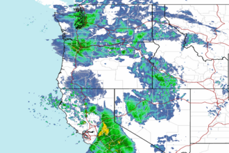 Northwest Radar