Casco Bay Marine Forecast
| Tonight...Sw Winds 5 To 10 Kt With Gusts Up To 20 Kt, Diminishing To Around 5 Kt After Midnight, Then Becoming E Around 5 Kt Late. Seas Around 2 Ft. |
| Wed...E Winds 5 To 10 Kt, Increasing To 10 To 15 Kt With Gusts Up To 20 Kt In The Afternoon. Seas Around 2 Ft. Showers. Vsby 1 To 3 Nm. |
| Wed Night...E Winds 5 To 10 Kt, Becoming N After Midnight. Seas Around 2 Ft. Showers Likely, Mainly In The Evening With Vsby 1 To 3 Nm. |
| Thu...Ne Winds 5 To 10 Kt. Seas Around 2 Ft. A Chance Of Showers In The Afternoon. |
| Thu Night...Ne Winds 10 To 15 Kt With Gusts Up To 20 Kt. Seas Around 2 Ft. Showers Likely. |
| Fri...Ne Winds Around 15 Kt With Gusts Up To 25 Kt. Seas 2 To 3 Ft. Showers Likely. |
| Fri Night...Ne Winds 10 To 15 Kt. Seas 2 To 3 Ft. Showers Likely, Mainly In The Evening. |
| Sat...Ne Winds Around 10 Kt, Becoming E In The Afternoon. Seas 2 To 3 Ft. A Chance Of Showers. |
| Sat Night...Sw Winds Around 10 Kt, Becoming W After Midnight. Seas 2 To 3 Ft. A Chance Of Showers. |
| Sun...S Winds 5 To 10 Kt. Seas 3 To 5 Ft. A Chance Of Showers. |
| Sun Night...S Winds 5 To 10 Kt. Seas 2 To 4 Ft. A Chance Of Showers. |
| Area Forecast Discussion National Weather Service Gray ME 833pm EDT Tuesday May 7 2024 Synopsis High pressure shifts out of the area tonight as low pressure approaches from the west. Widespread showers overspread the region on Wednesday with some thunder possible across southern and western NH Wednesday afternoon or evening. Another system follows for the end of the week, bringing more showers into the forecast. The unsettled, showery pattern may continue through the weekend. Near Term - Until 6am Wednesday Morning 8:30pm Just a quick update to add the coastal flood statement. Tides are running about 0.5 to 0.7ft above the astronomical tides, and should be right near minor flood stage during tonight's high tide. 7:15pm Mostly just tweaked temps for this evening based on trends and latest guidance. Warm temps have held on into the early evening hours, but should fall quickly over the next few hours before clouds spread in from the west overnight. Still watching the high tide in a few hours as well, which may require a statement if the water anomaly doesn't slacken off over the next hour or so as the sea breeze dissipates. Previous... The surface high over the area continues to get pushed gets slowly tonight, as weak surface wave moves in from the W. Surface flow generally becomes stagnant tonight, with zonal flow at 500 MB, and mostly weak flow at mid levels. It should stay fairly clear through the evening but cirrus starts to move in around the middle of the night, with lower clouds and showers possible in NH toward daybreak. Should see some decent cooling early, but the warm afternoon will counteract this a bit with a warmer starting point. So, mins drop into the 40s in many spots, with some colder upper 30’s in ME mtns, and maybe bottoming out around 50 in the more populated areas of S NH. .SHORT TERM /6am WEDNESDAY MORNING THROUGH THURSDAY/... Showers move in early in the morning across the CWA, with the N and E holding off until closer to midday. As the weak surface low approaches from the W, will pick up a light to moderate onshore flow which will limit initial warming in the morning, and kind of stall temps where there are by noon, or allow them to cool some closer to the coast. This should bring maxes into the 55-60 range across most of the area, but temps will drop closer to 50 during the afternoon near the coast. Also, once the onshore, E flow picks up could see some downsloping, which may allow spots in the CT valley to get into the low 60s. Some thunder is possible too, especially around midday as the marine layer will not be well established and there will more instability being generated from lowers levels. Best chance for T will be over the southern third of NH. The best chance for rain to become steadier at times will be Wednesday be from around midday Wednesday to around sunset. Showers linger into Wednesday evening but should see some drying after midnight, as we move to the back side of the low, and some drying behind it. Should also more fog late Wednesday night, and still a lot of clouds, as low level flow becomes weak again. Lows will be mainly in the 40s again. Long Term - Thursday Night Through Monday The pattern of unsettled weather will continue to finish up this workweek and the upcoming weekend with chances for rain each day, especially Thursday and Friday, and possibly light snow accumulations in the highest elevations. This is due to longwave troughing setting up basically over the eastern CONUS with embedded waves bringing these opportunities for precip. Starting Thursday...some drying aloft may provide a lull in precip, but with abundant moisture in the low levels, skies look to remain mostly cloudy with drizzle possible as well, especially in the morning. The better chances for rain arrive later in the day into Thursday night as shortwave energy moves overhead and low pressure moves offshore of the DELMARVA region. The better moisture will be closer to the low with a steady drop off with northward extend so the higher amounts and chances will be generally across southern NH and SW Maine. I have gone slightly cooler with high temps for Thursday as we'll have a light NE flow in addition to the expected cloud cover and increasing rain chances. This cloudy, cooler, and showery weather will likely persist into Friday, and we'll be holding onto the NE flow, so I have again kept temperature cooler than the NBM, which puts highs in the upper 40s to low 50s. Light snow accumulations are possible in the highest elevations for Thursday and Friday. The weekend doesn't look like a washout, but additional shortwaves will bring more chances for rain with some breaks in between. The global models are struggling with the timing and placement in these waves, so I have not deviated too much from the NBM chances Probability of Precipitation through the weekend. There are hints of a brief drier period around Monday in the operational GFS/ECMWF (European Centre for Medium-Range Weather Forecasts) with a shortwave ridge building in. However, the majority of the individual ensemble members continue to advertise additional Quantitative Precipitation Forecast in this time frame, and given the pattern, it seems like a good idea to keep a chance of rain showers in the forecast. Marine Short Term Winds/seas pick up a little out of the east and NE on Wed, but for a brief time, and are expected to stay below SCA criteria through Wednesday night. Long Term SCA (Small Craft Advisory) conditions are not expected on Thursday but will be possible Thursday night into the Friday timeframe with low pressure expected to pass near but just east of the waters. However, timing of the low pressure is uncertain right now. Depending on when this low passes, a period of improvement will probably occur, but another low pressure center may move across the waters in the Sunday to early next week time frame. Tides / Coastal Flooding High astronomical tides combined a small of storm surge may push water levels to minor flood stage along the coast with this evening's high tide, as well as the Wednesday night and Thursday night high tide. NOAA Gray/Portland ME Office - Watches - Warnings - Advisories ME...None. NH...None. Marine None. |
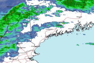 Portland ME Radar
 Northeast Radar