Englewood to Tarpon Springs FL out 20 NM Marine Forecast
| Today...South Winds 5 To 10 Knots, Becoming Southwest Late. Seas 1 Foot Or Less. Wave Detail: South 1 Foot At 5 Seconds. Bay And Inland Waters Light Chop. |
| Tonight...Southwest Winds 5 To 10 Knots, Becoming South 10 To 15 Knots After Midnight. Seas Around 2 Feet. Wave Detail: South 2 Feet At 5 Seconds. Bay And Inland Waters A Moderate Chop. |
| Thursday...South Winds 10 To 15 Knots. Seas Around 2 Feet. Wave Detail: South 2 Feet At 4 Seconds. Bay And Inland Waters A Moderate Chop. |
| Thursday Night...Southwest Winds Around 10 Knots. Seas Around 2 Feet. Wave Detail: South 2 Feet At 5 Seconds. Bay And Inland Waters Light Chop. |
| Friday...Southwest Winds 10 To 15 Knots. Seas Around 2 Feet. Wave Detail: Southwest 2 Feet At 4 Seconds. Bay And Inland Waters A Moderate Chop. A Slight Chance Of Showers And Thunderstorms In The Afternoon. |
| Friday Night...West Winds 10 To 15 Knots With Gusts Up To 20 Knots. Seas Around 2 Feet. Wave Detail: Southwest 2 Feet At 4 Seconds. Bay And Inland Waters A Moderate Chop. A Chance Of Showers With A Slight Chance Of Thunderstorms. |
| Saturday...Northwest Winds 10 To 15 Knots. Seas Around 2 Feet. Bay And Inland Waters A Moderate Chop. A Slight Chance Of Showers And Thunderstorms In The Morning. |
| Saturday Night...Northwest Winds 10 To 15 Knots. Seas Around 2 Feet. Bay And Inland Waters A Moderate Chop. |
| Sunday...Northeast Winds 5 To 10 Knots, Becoming Northwest In The Afternoon. Seas Around 2 Feet. Bay And Inland Waters Light Chop. Winds And Seas Higher In And Near Thunderstorms. |
| Area Forecast Discussion National Weather Service Tampa Bay Ruskin FL 331am EDT Wednesday May 8 2024 Marine Issued at 331am EDT Wednesday May 8 2024 Atlantic high pressure will ridge into the eastern Gulf of Mexico through Thursday night, with south and southeast flow less than 15 knots, turning onshore with the afternoon seabreeze. Dry air will prevent significant rain chances. The ridge will shift south Friday through the weekend as a couple of fronts push southeast into the waters. This will result in winds briefly increasing on Friday to around Exercise Caution levels and turning to westerly and then northerly. Rain chances will also increase on Friday and Saturday with the frontal passages. Fire Weather Issued at 331am EDT Wednesday May 8 2024 Relative humidity will drop to near critically low levels this afternoon. Even drier air is forecast to fill in on Thursday afternoon with a few hours of relative humidity percentages below 35 expected over the interior. However, wind speeds are not forecast to be fast enough to cause Red Flag conditions. Sea Breeze Thunderstorm Regime For Wednesday: 4 Sea Breeze Thunderstorm Regime For Thursday: 5 For additional information on sea breeze regimes, go to: https://www.weather.gov/tbw/ThunderstormClimatology NOAA Tampa FL Office: Watches - Warnings - Advisories FL...None. Gulf waters...None. |
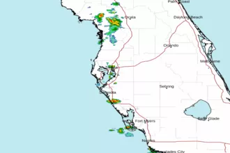 Tampa Bay FL Radar
 Gulf Radar