James Island to Point Grenville WA out 10 to 60 NM Marine Forecast
| Tonight...Nw Wind 15 To 20 Kt Becoming N 10 To 20 Kt After Midnight. Wind Waves 3 To 5 Ft. W Swell 6 Ft At 11 Seconds. |
| Thu...N Wind 5 To 15 Kt. Wind Waves 1 To 2 Ft. Nw Swell 6 Ft At 11 Seconds. |
| Thu Night...Nw Wind 15 To 20 Kt Becoming N 5 To 15 Kt After Midnight. Wind Waves 2 To 4 Ft Subsiding To 1 To 2 Ft After Midnight. W Swell 5 Ft At 11 Seconds. |
| Fri...N Wind 5 To 15 Kt. Wind Waves 1 To 2 Ft. Nw Swell 6 Ft At 11 Seconds. |
| Fri Night...Nw Wind 10 To 20 Kt. Wind Waves 2 To 4 Ft. Nw Swell 5 Ft At 9 Seconds And Nw 5 Ft At 0 Seconds. |
| Sat...Nw Wind 10 To 20 Kt. Wind Waves 2 To 4 Ft. Nw Swell 6 Ft At 6 Seconds And W 5 Ft At 0 Seconds. |
| Sat Night...Nw Wind 15 To 20 Kt. Wind Waves 2 To 4 Ft. Nw Swell 8 Ft At 8 Seconds And W 3 Ft At 7 Seconds. |
| Sun...Nw Wind 10 To 20 Kt Becoming 5 To 15 Kt. Wind Waves 2 To 4 Ft. Nw Swell 7 Ft. |
| Mon...Nw Wind 5 To 15 Kt. Wind Waves 2 To 4 Ft. W Swell 4 Ft. |
| Area Forecast Discussion National Weather Service Seattle WA 222pm PDT Wednesday May 8 2024 Synopsis A high pressure ridge will continue to build inland from the Pacific Coast through the first half of the weekend, allowing for a warming trend paired with dry conditions. Friday and Saturday will be the hottest days of the year so far. A weak system passing to the north of the area on Sunday will bring a cooling trend towards the end of the weekend and into early next week. * HEAT: Temperatures are on track to surpass 80 degrees for much of the lowlands on Friday and Saturday. Overnight low temperatures will also stay elevated in the 50s, providing little relief for the heat. * COLD WATER: Despite warm air temperatures, waterways across the region are still cold. Use caution if recreating around water. Short Term - Tonight Through Saturday High pressure will continue to build inland across western Washington today, allowing conditions to dry out and warm up. Clearing skies will allow temperatures to return to normal, with many locations already in the 60s as of 2pm PDT. Warming will continue into Thursday as the ridge overhead continues to amplify, with most areas reaching the mid to upper 70s. As low level flow turns offshore, areas along the coast and south of the Olympics will have the best shot at seeing the first 80 degree day of the year on Thursday. Overnight lows heading into Friday morning will jump up several degrees across the region, with most areas bottoming out in the low to mid 50s. Friday and Saturday will trend even warmer as high pressure aloft continues to dominate the weather pattern. Western Washington will see temperatures roughly 15 to 20 degrees above normal heading into the weekend, with most areas below 1000 ft reaching the 80s by Friday. The coast will see the warmest conditions on Friday under the influence of a thermal trough, and a switch to onshore flow on Saturday will cool the coastal areas roughly 10 to 15 degrees. The thermal trough will drift inland and allow areas mainly east of the Puget Sound to see the warmest conditions on Saturday. While the daily temperature records at SeaTac for Friday and Saturday are both set at 87 degrees (set in 2020 and 1971), reaching these records is not out of the realm of possibility. Current ensembles show a probability of 20 to 30 percent, slightly higher on Saturday as the warmer air mass nudges inland. Daytime temperatures will be the hottest of the year so far, and so will overnight lows in the mid 50s. SeaTac is on track to reach the daily record for warmest overnight low on Saturday morning, set at 55 degrees in 1988. Areas along the coast, including Quillayute, are also on track to see abnormally warm overnight lows heading into Saturday as the thermal trough shifts eastward. This will provide little relief to the weekend heat, which may pose a risk to individuals particularly sensitive to heat, especially outdoors without effective cooling or hydration. Long Term - Sunday Through Wednesday Temperatures will fall several degrees on Sunday as flow shifts onshore. Models continue to show a weak trough skirting us to the north, though this will be enough to moderate temperatures and cause the ridge to flatten. Ensembles remain in good agreement over the potential for drier and warmer conditions to continue into mid-week next week, aside from a slight chance of light shower activity over higher terrain along the periphery of the ridge. Lindeman Marine High pressure will continue to build over the waters into tonight with a thermal trough moving up the coast and advancing inland later Friday into Saturday. Northerly winds will remain a bit more elevated for the Coastal Waters into this evening with periods of SCA (Small Craft Advisory) winds for the central and southern inner Coastal Waters. In addition, brief west wind gusts will occur into this evening for the central Strait of Juan de Fuca. Winds will generally remain more northerly into the weekend before transitioning more onshore early next week. Seas of 5 to 8 feet through late week. JD Hydrology The daily hydrology discussion has ended until the start of the next rainy season; it will only be updated as needed. NOAA Seattle WA Office: Watches - Warnings - Advisories WA...None. PZ...Small Craft Advisory until 8pm PDT this evening for Central U.S. Waters Strait Of Juan De Fuca. Small Craft Advisory until 11pm PDT this evening for Coastal Waters From James Island To Point Grenville Out 10 Nm- Coastal Waters From Point Grenville To Cape Shoalwater Out 10 Nm. |
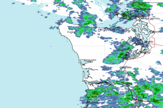 Langley Hill WA Radar
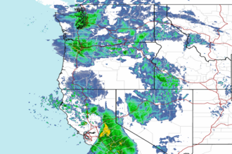 Northwest Radar