Laguna Madre from Port Mansfield to Baffin Bay Marine Forecast
| Rest Of Today...Southeast Winds 15 To 20 Knots. Choppy On The Bay. Hazy. |
| Tonight...Southeast Winds 15 To 20 Knots Becoming South 10 To 15 Knots After Midnight. Choppy On The Bay Becoming A Moderate Chop After Midnight. Hazy. Patchy Dense Fog After Midnight. |
| Thursday...South Winds 5 To 10 Knots Becoming Southeast 15 To 20 Knots In The Afternoon. Light Chop On The Bay Becoming Choppy In The Afternoon. Patchy Fog In The Morning. Hazy. |
| Thursday Night...Southeast Winds 15 To 20 Knots Decreasing To 5 To 10 Knots After Midnight. Choppy On The Bay Becoming Light Chop After Midnight. Hazy. |
| Friday...East Winds 10 To 15 Knots. A Moderate Chop On The Bay. Hazy In The Morning. |
| Friday Night...East Winds 10 To 15 Knots Decreasing To 5 To 10 Knots After Midnight. A Moderate Chop On The Bay Becoming Light Chop After Midnight. |
| Saturday...East Winds 10 To 15 Knots Increasing To 15 To 20 Knots In The Afternoon. A Moderate Chop On The Bay Becoming Choppy In The Afternoon. A Slight Chance Of Showers And Thunderstorms. |
| Saturday Night...East Winds 15 To 20 Knots Becoming Southeast Around 10 Knots After Midnight. Choppy On The Bay Becoming Light Chop After Midnight. A Slight Chance Of Showers And Thunderstorms. |
| Sunday...Southeast Winds 10 To 15 Knots. A Moderate Chop On The Bay. A Slight Chance Of Showers And Thunderstorms. |
| Sunday Night...Southeast Winds 10 To 15 Knots. A Moderate Chop On The Bay. Winds And Waves Higher In And Near Thunderstorms. |
| Area Forecast Discussion National Weather Service Brownsville TX 239pm CDT Wednesday May 8 2024 ...New SHORT TERM, LONG TER Marine .SHORT TERM... (Tonight through Thursday night) Issued at 236pm CDT Wednesday May 8 2024 Key Message: -Hot and unseasonably warm temperature are expected through the short term. -A Heat Advisory is in effect today until 7pm for inland Cameron, inland Willacy, inland Kenedy, Hidalgo and Brooks counties. -A Heat Advisory has been issued for Thursday from 1pm to 7pm for inland Cameron, inland Willacy, inland Kenedy counties. The going forecast remains on track with the main story for the short term remains the unseasonably warm temperatures across Deep South Texas and the Rio Grande Valley. Continued zonal to slightly southwesterly flow aloft will maintain subsidence aloft, and keep higher moisture content near the surface. Temperatures are expected to be even warmer on Thursday, with highs in the triple digits, away from the coast. The combination of high temperatures and dewpoints will make "real feel" temperatures on Thursday to rise to between 105 degrees and 113 degrees. A Heat Advisory has been issued for inland Cameron, inland Willacy and inland Kenedy counties for Thursday afternoon. Models continue to indicate a dryline inching eastward tomorrow afternoon will drop dewpoint levels enough that a Heat Advisory will not be needed further west. Overnight temperatures will once again remain in the mid to upper 70s. Outsize of the heat, hazy conditions will continue, mainly along the eastern half of the CWA, as southerly winds continue to bring in smoke from the fires in Mexico and Central America. Long Term (Friday through next Wednesday) Issued at 236pm CDT Wednesday May 8 2024 A cold front is expected to approach Deep South Texas and the Rio Grande Valley Friday morning. Once the front pushes through, temperatures are expected to be more seasonable in the upper 80s and lower 90s for the region. While the surface winds will shift behind the front towards the northeast, they will quickly shift back towards the east by Saturday and then southeast by Sunday. This will allow for temperatures to heat up again as the frontal boundary retreats backwards as a warm front. As such, temperatures will be back to being above normal with highs mostly in the mid to upper 90s and some places in the triple digits by Monday and lasting through the rest of the long term forecast period. Meanwhile, the overnight low temperatures are expected to be in the 70s. Plenty of low-level moisture along with a bit of forcing and instability could support the development of showers and thunderstorms during the passage of the cold front on Friday. A bit of a weak overrunning will support isolated to scattered showers and thunderstorms over the weekend. The return of the onshore flow on Sunday could also help a bit with the development of showers and thunderstorms on Sunday and Monday. Marine Issued at 236pm CDT Wednesday May 8 2024 Tonight through Thursday Night...Moderate southeast winds and moderate seas will prevail through the forecast period. Tonight, we could see some patchy fog/hazy conditions on the Gulf waters. Brief periods of Small Craft Exercise Caution conditions will be possible in the afternoon, especially across the Laguna Madre due to elevated winds. Friday through Next Wednesday...Stronger northeasterly winds are expected to prevail in the wake of the cold front that will move over the Lower Texas Coast on Friday into Saturday. Small Craft Exercise Caution or Small Craft Advisories are possible for Friday afternoon. Winds are then expected to weaken on Saturday, with light to moderate winds and moderate seas prevailing along the Lower Texas Coast through the rest of the period. NOAA Brownsville TX Office: Watches - Warnings - Advisories TX... Heat Advisory until 7pm CDT this evening for TXZ250-251-253>255- 353. Heat Advisory from 1pm to 7pm CDT Thursday for TXZ251-254-255. GM...None. |
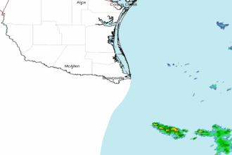 Brownsville TX Radar
 Gulf Radar