Manasquan Inlet to Little Egg Inlet NJ out 20 NM Marine Forecast
| Tonight...W Winds 10 To 15 Kt, Becoming Nw 5 To 10 Kt After Midnight. Seas 2 To 4 Ft. Wave Detail: S 3 Ft At 5 Seconds And E 2 Ft At 10 Seconds. |
| Thu...Ne Winds Around 5 Kt, Becoming E 10 To 15 Kt With Gusts Up To 20 Kt In The Afternoon. Seas 2 To 3 Ft. Wave Detail: S 2 Ft At 5 Seconds And E 1 Foot At 10 Seconds. A Chance Of Showers In The Morning, Then Showers Likely In The Afternoon. |
| Thu Night...E Winds 10 To 15 Kt With Gusts Up To 20 Kt. Seas 2 To 4 Ft. Wave Detail: E 3 Ft At 4 Seconds And E 3 Ft At 10 Seconds. Showers Likely. |
| Fri...E Winds 15 To 20 Kt. Seas 4 To 5 Ft. Wave Detail: Se 5 Ft At 6 Seconds. A Chance Of Showers In The Morning, Then Showers Likely In The Afternoon. |
| Fri Night...Ne Winds 10 To 15 Kt. Seas Around 4 Ft. Wave Detail: E 4 Ft At 7 Seconds And S 1 Foot At 8 Seconds. Showers Likely, Mainly In The Evening. |
| Sat...Ne Winds 10 To 15 Kt With Gusts Up To 20 Kt. Seas 3 To 5 Ft. Wave Detail: E 5 Ft At 8 Seconds And S 1 Foot At 7 Seconds. A Chance Of Showers In The Morning. |
| Sat Night...Se Winds 5 To 10 Kt. Seas 3 To 4 Ft. A Chance Of Showers. |
| Sun...E Winds Around 10 Kt. Seas 3 To 4 Ft. A Chance Of Showers. |
| Sun Night...N Winds Around 10 Kt, Becoming Nw After Midnight. Seas 3 To 4 Ft. |
| Mon...W Winds Around 10 Kt, Becoming S In The Afternoon. Seas Around 3 Ft. |
| Mon Night...S Winds 10 To 15 Kt. Seas Around 3 Ft. |
| Area Forecast Discussion National Weather Service Mount Holly NJ 431pm EDT Wednesday May 8 2024 Synopsis A front will move south of the area this evening and stall near southern Delaware and southern Maryland through Thursday, before an area of low pressure moves along it later Thursday. The front then remains to our south through Friday, before another low pressure system moves near the area later Friday into Friday night. Yet another weak low pressure system may move near the area Sunday, before high pressure builds south of the Mid-Atlantic region Sunday night into Monday. More unsettled weather could impact our area Tuesday into Wednesday as a storm system approaches the area. Near Term - Through Thursday Breezy the rest of the afternoon with southwest to west winds gusting 20-25 mph. Broad upper level pattern is more zonal overhead and with an airmass in place is quite dry through the column, kept afternoon POPs below 15 percent. That said, can't fully rule out a rogue gusty shower before sunset. As we head into tonight, initial area of low pressure continues moving east off the coast of New England and out to sea. This will push a weak cold front offshore through the evening. Meanwhile by the overnight period the next wave of low pressure will be approaching as it moves eastward through the midwestern states and this will start to push the front back to the north as a warm front. Clouds will once again be on the increase by the late overnight and it's possible we could see some showers start to enter the region towards dawn, however the trend has been slower with these arriving later. Expect lows ranging from the 50s north to the low 60s south. Forecast guidance continues to step back from the severe weather potential for Thursday, though the situation remains in a bit of a flux. A few things are working in favor for a diminished severe potential: 1) Guidance continues to trend further south with the track of our system, lending to a cooler, cloudier day 2) Convective-allowing models are suggesting an overnight MCS (Mesoscale Convective System, a complex of thunderstorms which becomes organized on a scale larger than the individual thunderstorms) across the southern Mid Atlantic will lift northward along a warm front and arrive around or shortly after daybreak Thursday, largely robbing our region of instability for much of the day. Because so much of the aforementioned elements depend on the evolution of severe weather occuring across the Tennessee River Valley today, there remains a higher than usual level of uncertainty within our forecast. At any rate, the warm front and how far north it is able to travel will be the limiting reagent for our weather tomorrow. North of the front will remain cloudy, showery, and overall dreary with temperatures stuck in the mid to upper 60s with an easterly flow. South of the front, warmer temperatures in the 70s with diurnal heating will lend to more instability developing through the day, resulting in a higher severe weather risk. At this point in the forecast, the frontal boundary is expected to stall out just south of the Delmarva Peninsula, keeping much of the severe weather potential in our forecast area suppressed. A few elevated storms cannot be ruled out, especially across the Delmarva and southern NJ, but the severe weather threat, if this forecast holds, is expected to be lower than previously forecast. Short Term - Thursday Night Through Friday Night Unsettled weather will continue for the Thursday night through Friday night time period as our area will be north of a frontal boundary located to our south, with a trough extending northward to our west. An area of low pressure is forecast to develop along this trough and move along the frontal boundary to our south through Friday night. There will be plenty of moisture and lift across the area, so showers and isolated thunderstorms will be possible. Long Term - Saturday Through Wednesday Unsettled weather continues still into the weekend with showers possible later Saturday into Sunday. For the first half of Saturday, our area will be in between one area of low pressure located offshore, and a second moving our of the Great Lakes region. As the low moves out of the Great Lakes region and approaches the Mid Atlantic later Saturday into Sunday, the potential for showers will increase across the area. A brief period of dry weather is expected later Sunday and Sunday night, and continuing into Monday as high pressure briefly builds to the south of the Mid Atlantic region. This dry weather will only be brief as chances will begin to increase Tuesday into Wednesday as a storm system approaches from the southwest. Marine Conditions will remain below Small Craft Advisory through Thursday. It will be quiet on the waters tonight but then expect more rounds of showers with some storms as well during the day Thursday as the next low approaches. East winds increase through the day to around 10-15 gusting to 20 knots by late day. Seas should generally be 2-4 feet. Outlook... Thursday night-Monday...Sub-Small Craft Advisory conditions are expected through the period, although winds may gust around 20 knots at times through the period, and seas may approach 4- 5 feet for a period on Friday. Tides / Coastal Flooding The new moon occurred Tuesday, May 7th, and this is resulting in high astronomical tides. An offshore wind today is lowering the surge some and some places may fall just short of advisory criteria for minor flooding tonight. Opted to keep the advisory as is given that several sites are forecast to reach minor flooding tonight and early Thursday morning. As a front settles to our south tonight, an onshore flow will develop and strengthen some through the end of the week. While the astronomical tides will be gradually lowering as we get farther away from the new moon, the onshore flow should boost the surge at least some. There is some guidance that shows moderate flooding at some coastal sites, however opted to keep it as minor given the uncertainty. The Coastal Flood Advisory for minor tidal flooding remains in effect for the Atlantic coastal zones, the Delaware Bay, and the tidal Delaware River with the high tide cycle tonight and early Thursday morning. Additional minor coastal flooding is forecast with the evening/overnight high tides through the end of the week. Flooding is not expected at this time for our Maryland zones along the Chesapeake. NOAA Mount Holly NJ Office: Watches - Warnings - Advisories PA...Coastal Flood Advisory from 1am to 6am EDT Thursday for PAZ070-071-106. NJ...Coastal Flood Advisory from 10pm this evening to 2am EDT Thursday for NJZ016. Coastal Flood Advisory from 8pm this evening to 2am EDT Thursday for NJZ012>014-020>027. Coastal Flood Advisory from 1am to 6am EDT Thursday for NJZ017>019. DE...Coastal Flood Advisory from 10pm this evening to 2am EDT Thursday for DEZ001. Coastal Flood Advisory from 8pm this evening to 2am EDT Thursday for DEZ002>004. MD...None. Marine None. |
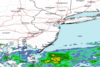 Mount Holly NJ Radar
 Northeast Radar
 East Coast Satellite