Point Grenville to Cape Shoalwater WA out 10 NM Marine Forecast
| Today...N Wind 5 To 15 Kt Becoming Nw 10 To 20 Kt In The Afternoon. Wind Waves 1 To 2 Ft Building To 2 To 4 Ft In The Afternoon. W Swell 6 Ft At 11 Seconds. |
| Tonight...Nw Wind 15 To 25 Kt Becoming N 10 To 20 Kt After Midnight. Wind Waves 3 To 5 Ft. Nw Swell 6 Ft At 10 Seconds. |
| Thu...Ne Wind To 10 Kt Becoming N 5 To 15 Kt In The Afternoon. Wind Waves 2 To 3 Ft. W Swell 5 Ft At 10 Seconds. |
| Thu Night...Nw Wind 5 To 15 Kt Becoming N To 10 Kt After Midnight. Wind Waves 2 To 3 Ft. W Swell 6 Ft At 9 Seconds. |
| Fri...Ne Wind To 10 Kt Becoming N 5 To 15 Kt In The Afternoon. Wind Waves 2 To 3 Ft. W Swell 6 Ft At 11 Seconds. |
| Fri Night...Nw Wind 10 To 20 Kt Becoming 5 To 15 Kt After Midnight. Wind Waves 2 To 4 Ft. W Swell 5 Ft At 8 Seconds. |
| Sat...Nw Wind 5 To 15 Kt. Wind Waves 2 To 3 Ft. W Swell 2 To 6 Ft Building To 4 To 7 Ft. |
| Sun...Nw Wind 5 To 15 Kt. Wind Waves 2 To 3 Ft. Nw Swell 5 To 6 Ft Becoming W 1 To 2 Ft. |
| Area Forecast Discussion National Weather Service Seattle WA 829am PDT Wednesday May 8 2024 High pressure will build inland through the rest of the week and into the weekend, kicking off a warming trend. The lowlands are on track to see temperatures in the 80s on Friday and Saturday with elevated overnight lows in the low to mid 50s. While air temperatures will be warm, water temperatures will still be cool enough to pose a safety risk. No updates to the forecast. Synopsis A ridge of high pressure aloft will begin to build into the area today then strengthen toward the end of the week as thermally induced low pressure near the surface expands northward into the area. Dry conditions will prevail along with the warmest temperatures of the year thus far on Friday and Saturday. A weak system passing to the north of the area will bring a cooling trend early next week. Short Term - Today through Friday Ridging at the surface and aloft is building into the region today. With plenty of sunshine today, temperatures will bounce back to near climatological norms. The upper ridge continues to strengthen on Thursday as low level northerly flow turns offshore in response to thermally induced low pressure expanding northward along the coast. High temperatures will warm several degrees on Thursday...especially along the coast where offshore flow will boost temps into the mid 70s to near 80. 70s will be common across interior areas from the Seattle area southward. The upper ridge weakens slightly on Friday, but 500 millibar heigheights remain in the vicinity of 580 dam. Coastal areas are likely to see another round of warm temperatures before the sea breeze kicks in late and the thermal trough makes the jump inland. Friday will be the warmest day thus far this year for much of the interior lowlands with 70s in the north interior and 80+ from the Seattle area southward. Long Term - Saturday Through Tuesday A switch to onshore flow on Saturday will cool coastal areas some 15 to 20 degrees or so compared to Friday while interior areas remain warm with the thermal trough in place. Sunday and beyond, the ridge is expected to flatten as a couple of systems pass by to our north. The main effect will be to cool temperatures back to near or slightly above seasonal levels. With the exception of a few possible showers in the North Cascades, the remainder of the area looks to remain on the dry side. 27 Marine High pressure will continue to build over the waters today, with a thermally induced area of low pressure moving up the coast, and advancing inland Friday. Westerly winds will increase again this afternoon into this evening for the central Strait of Juan de Fuca with a Small Craft Advisory in place. In addition, a SCA (Small Craft Advisory) has been issued for the central and southern inner coastal waters this afternoon into this evening. Increasing northerly winds during this period will allow for gusts near 25 kt before winds slowly subside later tonight. Otherwise, primarily northerly winds through late week. Hydrology The daily hydrology discussion has ended until the start of the next rainy season; it will only be updated as needed. NOAA Seattle WA Office: Watches - Warnings - Advisories WA...None. PZ...Small Craft Advisory until 2am PDT Thursday for Central U.S. Waters Strait Of Juan De Fuca. Small Craft Advisory until 8am PDT this morning for Admiralty Inlet East Entrance U.S. Waters Strait Of Juan De Fuca. |
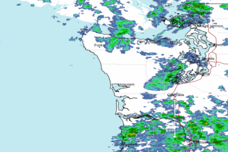 Langley Hill WA Radar
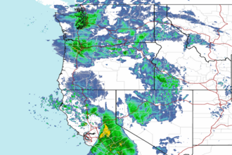 Northwest Radar