Port Aransas to Matagorda Ship Channel Marine Forecast
| Rest Of Tonight...South Winds Around 10 Knots. Seas 3 To 4 Feet, Occasionally To 5 Feet. Wave Detail: Southeast 4 Feet At 7 Seconds. Patchy Fog Late. |
| Wednesday...South Winds 10 To 15 Knots. Seas 3 To 4 Feet, Occasionally To 5 Feet. Wave Detail: Southeast 4 Feet At 7 Seconds. Patchy Fog In The Morning. |
| Wednesday Night...South Winds 10 To 15 Knots. Seas 3 To 4 Feet, Occasionally To 5 Feet. Wave Detail: Southeast 4 Feet At 7 Seconds. |
| Thursday...Southeast Winds Around 10 Knots. Seas 3 To 4 Feet, Occasionally To 5 Feet. Wave Detail: Southeast 4 Feet At 7 Seconds. |
| Thursday Night...Southeast Winds 5 To 10 Knots, Becoming Northeast After Midnight. Seas 3 To 4 Feet, Occasionally To 5 Feet. Wave Detail: Southeast 4 Feet At 7 Seconds. |
| Friday...Northeast Winds 15 To 20 Knots With Gusts Up To 25 Knots. Seas 3 To 5 Feet, Occasionally To 6 Feet. Wave Detail: Northeast 3 Feet At 4 Seconds And Southeast 3 Feet At 7 Seconds. |
| Friday Night...Northeast Winds 10 To 15 Knots With Gusts Up To 20 Knots. Seas 3 To 4 Feet, Occasionally To 5 Feet. |
| Saturday...Northeast Winds Around 15 Knots. Seas 3 To 4 Feet, Occasionally To 5 Feet. |
| Saturday Night...East Winds Around 15 Knots, Diminishing To Around 10 Knots After Midnight. Seas Around 3 Feet. |
| Sunday...East Winds 10 To 15 Knots. Seas Around 3 Feet. A Chance Of Showers. |
| Sunday Night...Southeast Winds 10 To 15 Knots. Seas 3 To 4 Feet, Occasionally To 5 Feet. A Chance Of Showers In The Evening. |
| Area Forecast Discussion National Weather Service Corpus Christi TX 635pm CDT Tuesday May 7 2024 Long Term (Thursday through next Monday) Issued at 159pm CDT Tuesday May 7 2024 Key Messages: ▶ Moderate to Major risk of heat-related impacts with near record high temperatures Thursday ▶ Weak cold front early Friday morning ▶ Low (20%) chance of showers and thunderstorms Friday and Saturday, increasing to a low to moderate (30-40%) chance Sunday and Monday Near record high temperatures are expected Thursday as near climatological max 850mb temperatures mix down and cause a moderate to major heat risk across South Texas. Laredo's record high is 108 back in 2011 forecast to reach 107 and Corpus Christi's record high is 100 back in 1998 forecast to reach 98. Heat index values are expected to reach the triple digits across all of South Texas with a medium chance of at least 110 over Nueces and Kleberg counties. A Heat Advisory may be needed as this level of heat affects most individuals sensitive to heat, especially those without effective cooling. Thankfully, a weak cold front will pass through the area overnight Thursday night into early Friday morning, resulting in relief from the dangerous heat with highs and feels-like temperatures in the upper 80s to around 90. In addition, isentropic lift with weak condensation deficits combined with well above normal moisture (PWATs (Precipitable Waters) ~ 1.75") will lead to a low (20%) chance of showers and thunderstorms Friday and Saturday. The boundary will retreat northwestward as a warm front Saturday afternoon into evening. Another mid-level trough will progress eastward across the Great Plains early next week and act as a reinforcing surge of high pressure, pushing the front back into South Texas and meander Sunday evening into Monday. There are model discrepancies with the mid-level flow, resulting in low confidence with the position of the front. Either way, the close proximity to the front and even higher moisture (99th percentile with PWATs (Precipitable Waters) near 2.0") will lead to a better (30-40%) chance of showers and thunderstorms Sunday and Monday. On the bright side, there is a less than 10% chance of temperatures reaching 90 degrees east of Duval County this weekend! Marine Light to moderate onshore winds can be expected Tonight through Thursday night. A cold front will move off the coast early Friday morning. Winds will shift to the northeast and strengthen to moderate levels Friday and Saturday. Winds become easterly on Sunday. There is a 20 percent chance of showers and thunderstorms Saturday, increasing to a medium 30 to 40 percent chance Sunday through Monday. NOAA Corpus Christi TX Office: Watches - Warnings - Advisories TX... Heat Advisory from 1pm to 7pm CDT Wednesday for TXZ241>243. GM...None. |
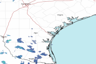 Corpus Christi TX Radar
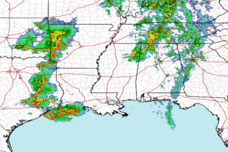 Gulf Radar