Port Mansfield, TX to the Rio Grande River Marine Forecast
| Tonight...Northeast Winds 20 To 25 Knots With Gusts Up To 30 Knots, Becoming North 15 To 20 Knots Early This Morning. Seas 7 To 10 Feet, Occasionally To 13 Feet. Wave Detail: Northeast 9 Feet At 8 Seconds And North 2 Feet At 5 Seconds. A Slight Chance Of Showers This Evening. |
| Monday...North Winds 15 To 20 Knots, Diminishing To 10 To 15 Knots In The Afternoon. Seas 6 To 8 Feet, Occasionally To 10 Feet, Subsiding To 4 To 6 Feet, Occasionally To 8 Feet In The Afternoon. Wave Detail: Northeast 7 Feet At 8 Seconds And North 1 Foot At 5 Seconds, Becoming Northeast 5 Feet At 8 Seconds And North 1 Foot At 4 Seconds. |
| Monday Night...Northeast Winds 5 To 10 Knots, Becoming East After Midnight. Seas 3 To 4 Feet. Wave Detail: East 4 Feet At 7 Seconds. |
| Tuesday...Southeast Winds Around 10 Knots. Seas 3 To 4 Feet. Wave Detail: East 3 Feet At 7 Seconds. A Slight Chance Of Showers In The Afternoon. |
| Tuesday Night...Southeast Winds 10 To 15 Knots. Seas 3 To 4 Feet. Wave Detail: East 3 Feet At 7 Seconds And Southeast 3 Feet At 6 Seconds. A Chance Of Showers In The Evening, Then A Chance Of Showers With A Slight Chance Of Thunderstorms After Midnight. |
| Wednesday...South Winds Around 10 Knots. Seas 3 To 4 Feet. Wave Detail: East 2 Feet At 7 Seconds And Southeast 2 Feet At 6 Seconds. Showers Likely With A Slight Chance Of Thunderstorms. |
| Wednesday Night...South Winds Around 10 Knots. Seas 3 To 4 Feet. A Slight Chance Of Showers In The Evening. |
| Thursday...South Winds 5 To 10 Knots, Becoming Southeast Late In The Afternoon. Seas 2 To 3 Feet. |
| Thursday Night...Southeast Winds Around 10 Knots, Becoming Northeast After Midnight. Seas 2 To 3 Feet. |
| Friday...Northeast Winds 5 To 10 Knots. Seas 2 To 3 Feet. |
| Friday Night...East Winds Around 10 Knots, Becoming Southeast After Midnight. Seas 2 To 4 Feet. Winds And Seas Higher In And Near Thunderstorms. |
| Area Forecast Discussion National Weather Service Brownsville TX 1226pm CST Sunday Dec 14 2025 ...NewARINE... .KEY MESSAGES... Updated at 1216pm CST Sunday Dec 14 2025 * Hazardous marine and coastal conditions persist through Monday in response to a cold front. * Gusty winds and near to below average temperatures today and Monday. * Warmer than normal temperatures and mainly rain-free weather will prevail through next week, with a chance of showers Tuesday/Wednesday. Issued at 1216pm CST Sunday Dec 14 2025 A cold front has worked its way across Deep South Texas this morning, leaving cooler temperatures, gusty winds, showers, and coastal hazards in its wake. Showers against the front are currently moving past the Rio Grande River, and will continue to move south of the region through the afternoon. Dry air behind the front will keep rain chances low for late Sunday afternoon onwards, but an isolated shower or two cannot be ruled out. Gusty northerly winds from 15-25 mph gusting 20 to around 40 mph will continue through the afternoon, beginning to lessen overnight. Stronger, gustier winds will be nearer the coast. Coastal hazards behind the cold front include a Coastal Flood Statement, in effect from 12pm Sunday to midnight, a High Surf Advisory from 3pm Sunday to 6am Monday, and a High Risk of Rip Currents through 6pm Monday. Despite astronomically low tides and a waning crescent moon, strong northerly winds behind the front will build seas and may cause narrow beaches and runup. Temporary relief in temperatures following cold frontal passage. with near to just below average temps through Monday. High temperatures were reached this morning as cold air advection begins to drain cooler air into the CWA, dropping temperatures through the overnight. Monday morning low temperatures in the 40s, 50s along the immediate coast and RGV. Mostly cloudy skies Monday morning begin to break up through the afternoon, with high temperatures in the 60s. Dry air behind the front will keep rain chances low (20% or less) through Tuesday, when southeasterly flow returns moisture into the atmosphere. An approaching disturbance midweek will elevate rain chances Tuesday night through Wednesday - moderate along the coast and low inland. In the latter half of the week, a zonal synoptic setup is expected to dominate, leaving benign weather and a chance for warm temperatures to rise to above average. Marine Issued at 1216pm CST Sunday Dec 14 2025 Unfavorable marine conditions are in place behind a cold front passage Sunday morning. Strong to near gale northerly winds with gusts to gale force will continue Sunday afternoon and ahead of sunrise Monday. Seas build to rough Sunday afternoon and persist overnight, decreasing during Monday. Moderate winds turn southeasterly Tuesday and continue through much of the week. Isolated to scattered showers and thunderstorms diminish Sunday evening as dry air enters behind the front. Low chances of rain continue until Tuesday evening, when medium to high (40 to 70 percent) chances return through Wednesday. Favorable conditions to persist Tuesday through late week. NOAA Brownsville TX Office: Watches - Warnings - Advisories TX...High Rip Current Risk through Monday afternoon for TXZ451-454- 455. High Surf Advisory until 6am CST Monday for TXZ451-454-455. GM...Small Craft Advisory until 6am CST Monday for GMZ130-132-135. Gale Warning until 6am CST Monday for GMZ150-155-170-175. |
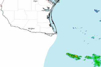 Brownsville TX Radar
 Gulf Radar